Virgil geodata
Virgil (Ontario) is a populated place; located in Canada in America/Toronto (GMT-4) time zone. With population of 2,937 people, there are 622 cities with bigger population in this country. Compared to other cities in Canada, 96.1% of cities are located further ↑North; 50.4% of cities are located further →East and 61.7% of cities have higher elevation than Virgil. Note1


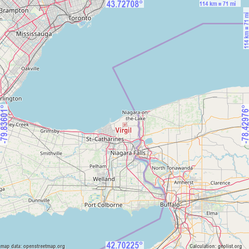
Virgil GPS coordinates[2]
43° 13' 0.552" North, 79° 7' 58.368" West
| Map corner | latitude | longitude |
|---|---|---|
| Upper-left | 43.72708°, | -79.83601° |
| Center: | 43.21682°, | -79.13288° |
| Lower-right: | 42.70225°, | -78.42976° |
| Map W x H: | 114×113.9 km | = 70.8×70.8mi |
| max Lat: | 73.03752° ⇑96.1% North |
| Virgil: | 43.21682° |
| min Lat: | ⇓3.9% South 42.05009° |
| min Long | Virgil | max Long |
| -139.43328° | -79.13288° | -52.70931° |
| W 49.6%⇐ | ⇒50.4% E |
Elevation
Elevation of Virgil is 92 m = 302 ft, and this is 162.4 m = 533 ft below average elevation for this country.
| Max E: |
1518 m = 4980 ft | 61.7% |
| Avg. | 254.4 m = 835 ft | |
| Virgil | 92 m = 302 ft | |
Min E: |
-2 m = -7 ft | 38.3% |
See also: Canada elevation on elevation.city.
Geographical zone
Virgil is located in North temperate zone (between Tropic of Cancer and the Arctic Circle). Distance of this Northern Tropic circle is 2199.3 km =1366.6 mi to South.| Distance of | km | miles | from Virgil |
|---|---|---|---|
| North Pole | 5201.8 | 3232.2 | to North |
| Arctic Circle | 2595.9 | 1613 | to North |
| Tropic Cancer | 2199.3 | 1366.6 | to South |
| Equator | 4805.3 | 2985.9 | to South |


Nearby cities:
15 places around Virgil: (largest is in red/bold)
• Binbrook
56 km =34.8 mi,  259°
259°
• East York
55 km =34.2 mi,  343°
343°
• Fort Erie
38.8 km =24.1 mi,  155°
155°
• Hamilton
58.2 km =36.2 mi,  273°
273°
• Mississauga
58.5 km =36.4 mi,  313°
313°
• Mississauga Beach
6.9 km =4.3 mi,  36°
36°
• Niagara Falls
14.1 km =8.8 mi, 157°
• Oakville
51.5 km =32 mi,  300°
300°
• Port Colborne
36.1 km =22.4 mi,  192°
192°
• St. Catharines
10.2 km =6.3 mi,  240°
240°
• Thorold
12.4 km =7.7 mi,  205°
205°
• Thunder Bay
38.3 km =23.8 mi,  167°
167°
• Toronto
58.4 km =36.3 mi, 336°
• Vineland
22.9 km =14.2 mi,  251°
251°
• Welland
27.6 km =17.1 mi,  200°
200°
Sources, notices
• [Note1] Compared only with cities in Canada existing in our database
• [Src1] Map data: © OpenStreetMap contributors (CC-BY-SA)
• [Src2] Other city data from geonames.org with taken over terms of usage.
• [Src3] Geographical zone / Annual Mean Temperature by Robert A. Rohde @ Wikipedia
