Oromocto geodata
Oromocto (New Brunswick) is a populated place; located in Canada in America/Moncton (GMT-3) time zone. With population of 8,805 people, there are 342 cities with bigger population in this country. Compared to other cities in Canada, 67.1% of cities are located further ↑North; 87.3% of cities are located further ←West and 82.9% of cities have higher elevation than Oromocto. Note1


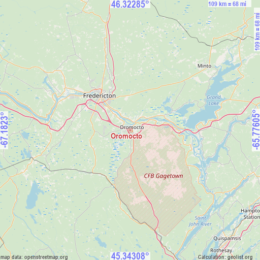
Oromocto GPS coordinates[2]
45° 50' 6.432" North, 66° 28' 45.012" West
| Map corner | latitude | longitude |
|---|---|---|
| Upper-left | 46.32285°, | -67.1823° |
| Center: | 45.83512°, | -66.47917° |
| Lower-right: | 45.34308°, | -65.77605° |
| Map W x H: | 108.9×108.9 km | = 67.7×67.7mi |
| max Lat: | 73.03752° ⇑67.1% North |
| Oromocto: | 45.83512° |
| min Lat: | ⇓32.9% South 42.05009° |
| min Long | Oromocto | max Long |
| -139.43328° | -66.47917° | -52.70931° |
| W 87.3%⇐ | ⇒12.7% E |
Elevation
Elevation of Oromocto is 27 m = 89 ft, and this is 227.4 m = 746 ft below average elevation for this country.
| Max E: |
1518 m = 4980 ft | 82.9% |
| Avg. | 254.4 m = 835 ft | |
| Oromocto | 27 m = 89 ft | |
Min E: |
-2 m = -7 ft | 17.1% |
See also: Canada elevation on elevation.city.
Geographical zone
Oromocto is located in North temperate zone (between Tropic of Cancer and the Arctic Circle). Distance of this North polar circle is 2304.8 km =1432.1 mi to North.| Distance of | km | miles | from Oromocto |
|---|---|---|---|
| North Pole | 4910.7 | 3051.4 | to North |
| Arctic Circle | 2304.8 | 1432.1 | to North |
| Tropic Cancer | 2490.5 | 1547.5 | to South |
| Equator | 5096.4 | 3166.8 | to South |


Nearby cities:
15 places around Oromocto: (largest is in red/bold)
• Carlisle Road
27.5 km =17.1 mi,  308°
308°
• Fredericton
18.9 km =11.7 mi, 310°
• Hampton
59.3 km =36.8 mi,  125°
125°
• Hartland
95.3 km =59.2 mi,  302°
302°
• Keswick Ridge
36.2 km =22.5 mi, 300°
• Lincoln
10.8 km =6.7 mi, 312°
• Nackawic
61.6 km =38.3 mi,  286°
286°
• New Maryland
15.4 km =9.6 mi, 288°
• Noonan
15.2 km =9.4 mi,  344°
344°
• Pepper Creek
15.7 km =9.8 mi,  326°
326°
• Saint Andrews
95.8 km =59.5 mi,  207°
207°
• Saint John
70.3 km =43.7 mi,  152°
152°
• Starlight Village
23.1 km =14.4 mi,  283°
283°
• Sussex
76.4 km =47.5 mi,  99°
99°
• Wells
65.5 km =40.7 mi,  138°
138°
Sources, notices
• [Note1] Compared only with cities in Canada existing in our database
• [Src1] Map data: © OpenStreetMap contributors (CC-BY-SA)
• [Src2] Other city data from geonames.org with taken over terms of usage.
• [Src3] Geographical zone / Annual Mean Temperature by Robert A. Rohde @ Wikipedia
