Deux-Montagnes geodata
Deux-Montagnes (Quebec) is a populated place; located in Canada in America/Toronto (GMT-4) time zone. With population of 17,402 people, there are 212 cities with bigger population in this country. Compared to other cities in Canada, 73.4% of cities are located further ↑North; 63.6% of cities are located further ←West and 81.9% of cities have higher elevation than Deux-Montagnes. Note1


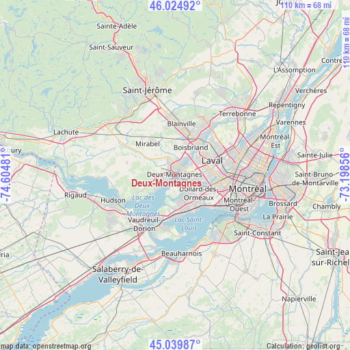
Deux-Montagnes GPS coordinates[2]
45° 32' 4.38" North, 73° 54' 6.048" West
| Map corner | latitude | longitude |
|---|---|---|
| Upper-left | 46.02492°, | -74.60481° |
| Center: | 45.53455°, | -73.90168° |
| Lower-right: | 45.03987°, | -73.19856° |
| Map W x H: | 109.5×109.5 km | = 68×68mi |
| max Lat: | 73.03752° ⇑73.4% North |
| Deux-Montagnes: | 45.53455° |
| min Lat: | ⇓26.6% South 42.05009° |
| min Long | Deux-Montagnes | max Long |
| -139.43328° | -73.90168° | -52.70931° |
| W 63.6%⇐ | ⇒36.4% E |
Elevation
Elevation of Deux-Montagnes is 29 m = 95 ft, and this is 225.4 m = 740 ft below average elevation for this country.
| Max E: |
1518 m = 4980 ft | 81.9% |
| Avg. | 254.4 m = 835 ft | |
| Deux-Montagnes | 29 m = 95 ft | |
Min E: |
-2 m = -7 ft | 18.1% |
See also: Canada elevation on elevation.city.
Geographical zone
Deux-Montagnes is located in North temperate zone (between Tropic of Cancer and the Arctic Circle). Distance of this North polar circle is 2338.2 km =1452.9 mi to North.| Distance of | km | miles | from Deux-Montagnes |
|---|---|---|---|
| North Pole | 4944.1 | 3072.1 | to North |
| Arctic Circle | 2338.2 | 1452.9 | to North |
| Tropic Cancer | 2457 | 1526.7 | to South |
| Equator | 5063 | 3146 | to South |


Nearby cities:
15 places around Deux-Montagnes: (largest is in red/bold)
• Baie-D'Urfé
13.5 km =8.4 mi,  184°
184°
• Beaconsfield
11.6 km =7.2 mi,  166°
166°
• Blainville
14.8 km =9.2 mi,  5°
5°
• Boisbriand
10.6 km =6.6 mi,  30°
30°
• Dollard-Des Ormeaux
7.5 km =4.7 mi,  126°
126°
• Dorval
15.1 km =9.4 mi, 129°
• Kirkland
9.8 km =6.1 mi,  163°
163°
• Pointe-Calumet
6.3 km =3.9 mi,  232°
232°
• Pointe-Claire
11.6 km =7.2 mi,  145°
145°
• Rosemère
13.6 km =8.5 mi,  35°
35°
• Saint-Eustache
3.4 km =2.1 mi,  354°
354°
• Saint-Joseph-du-Lac
7.6 km =4.7 mi,  269°
269°
• Sainte-Anne-de-Bellevue
14.7 km =9.1 mi,  193°
193°
• Sainte-Marthe-sur-le-Lac
2.4 km =1.5 mi, 266°
• Sainte-Thérèse
13 km =8.1 mi, 26°
Sources, notices
• [Note1] Compared only with cities in Canada existing in our database
• [Src1] Map data: © OpenStreetMap contributors (CC-BY-SA)
• [Src2] Other city data from geonames.org with taken over terms of usage.
• [Src3] Geographical zone / Annual Mean Temperature by Robert A. Rohde @ Wikipedia
