Saint-Canut geodata
Saint-Canut (Quebec) is a populated place; located in Canada in America/Toronto (GMT-4) time zone. With population of 10,643 people, there are 299 cities with bigger population in this country. Compared to other cities in Canada, 69.1% of cities are located further ↑North; 61.6% of cities are located further ←West and 66.8% of cities have higher elevation than Saint-Canut. Note1


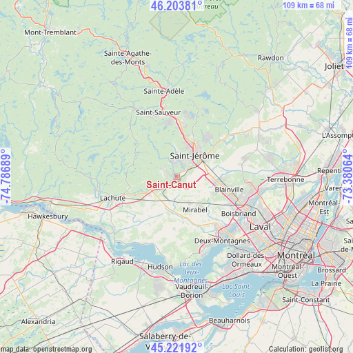
Saint-Canut GPS coordinates[2]
45° 42' 54.072" North, 74° 5' 1.536" West
| Map corner | latitude | longitude |
|---|---|---|
| Upper-left | 46.20381°, | -74.78689° |
| Center: | 45.71502°, | -74.08376° |
| Lower-right: | 45.22192°, | -73.38064° |
| Map W x H: | 109.2×109.2 km | = 67.9×67.9mi |
| max Lat: | 73.03752° ⇑69.1% North |
| Saint-Canut: | 45.71502° |
| min Lat: | ⇓30.9% South 42.05009° |
| min Long | Saint-Canut | max Long |
| -139.43328° | -74.08376° | -52.70931° |
| W 61.6%⇐ | ⇒38.4% E |
Elevation
Elevation of Saint-Canut is 68 m = 223 ft, and this is 186.4 m = 612 ft below average elevation for this country.
| Max E: |
1518 m = 4980 ft | 66.8% |
| Avg. | 254.4 m = 835 ft | |
| Saint-Canut | 68 m = 223 ft | |
Min E: |
-2 m = -7 ft | 33.2% |
See also: Canada elevation on elevation.city.
Geographical zone
Saint-Canut is located in North temperate zone (between Tropic of Cancer and the Arctic Circle). Distance of this North polar circle is 2318.1 km =1440.4 mi to North.| Distance of | km | miles | from Saint-Canut |
|---|---|---|---|
| North Pole | 4924 | 3059.6 | to North |
| Arctic Circle | 2318.1 | 1440.4 | to North |
| Tropic Cancer | 2477.1 | 1539.2 | to South |
| Equator | 5083 | 3158.4 | to South |


Nearby cities:
15 places around Saint-Canut: (largest is in red/bold)
• Blainville
16.5 km =10.3 mi,  108°
108°
• Lac-Alouette
14.9 km =9.3 mi,  40°
40°
• Lachute
20.6 km =12.8 mi,  249°
249°
• Mirabel
7.2 km =4.5 mi,  179°
179°
• Piedmont
20.9 km =13 mi,  349°
349°
• Prévost
16.9 km =10.5 mi,  0°
0°
• Saint-Colomban
4.3 km =2.7 mi,  298°
298°
• Saint-Eustache
21.7 km =13.5 mi,  140°
140°
• Saint-Joseph-du-Lac
21.2 km =13.2 mi,  161°
161°
• Saint-Jérôme
9.6 km =6 mi, 40°
• Saint-Sauveur
20.5 km =12.7 mi,  338°
338°
• Saint-Sauveur-des-Monts
21.5 km =13.4 mi, 342°
• Sainte-Sophie
18.2 km =11.3 mi,  51°
51°
• Sainte-Thérèse
21.6 km =13.4 mi, 112°
• Terrasse-des-Pins
16.7 km =10.4 mi, 4°
Sources, notices
• [Note1] Compared only with cities in Canada existing in our database
• [Src1] Map data: © OpenStreetMap contributors (CC-BY-SA)
• [Src2] Other city data from geonames.org with taken over terms of usage.
• [Src3] Geographical zone / Annual Mean Temperature by Robert A. Rohde @ Wikipedia
