Saint-Colomban geodata
Saint-Colomban (Quebec) is a seat of a third-order administrative division; located in Canada in America/Toronto (GMT-4) time zone. In our database, there are 1177 cities with bigger population. Compared to other cities in Canada, 68.6% of cities are located further ↑North; 61.3% of cities are located further ←West and 53.7% of cities have higher elevation than Saint-Colomban. Note1


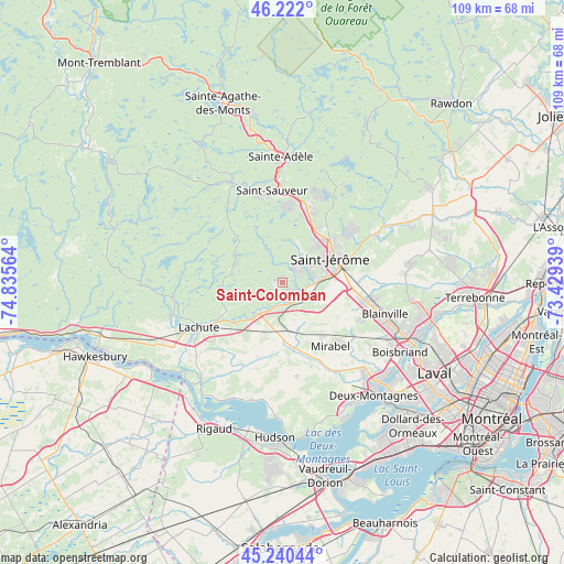
Saint-Colomban GPS coordinates[2]
45° 44' 0.168" North, 74° 7' 57.036" West
| Map corner | latitude | longitude |
|---|---|---|
| Upper-left | 46.222°, | -74.83564° |
| Center: | 45.73338°, | -74.13251° |
| Lower-right: | 45.24044°, | -73.42939° |
| Map W x H: | 109.1×109.1 km | = 67.8×67.8mi |
| max Lat: | 73.03752° ⇑68.6% North |
| Saint-Colomban: | 45.73338° |
| min Lat: | ⇓31.4% South 42.05009° |
| min Long | Saint-Colomban | max Long |
| -139.43328° | -74.13251° | -52.70931° |
| W 61.3%⇐ | ⇒38.7% E |
Elevation
Elevation of Saint-Colomban is 149 m = 489 ft, and this is 105.4 m = 346 ft below average elevation for this country.
| Max E: |
1518 m = 4980 ft | 53.7% |
| Avg. | 254.4 m = 835 ft | |
| Saint-Colomban | 149 m = 489 ft | |
Min E: |
-2 m = -7 ft | 46.3% |
See also: Canada elevation on elevation.city.
Geographical zone
Saint-Colomban is located in North temperate zone (between Tropic of Cancer and the Arctic Circle). Distance of this North polar circle is 2316.1 km =1439.2 mi to North.| Distance of | km | miles | from Saint-Colomban |
|---|---|---|---|
| North Pole | 4922 | 3058.4 | to North |
| Arctic Circle | 2316.1 | 1439.2 | to North |
| Tropic Cancer | 2479.2 | 1540.5 | to South |
| Equator | 5085.1 | 3159.7 | to South |


Nearby cities:
15 places around Saint-Colomban: (largest is in red/bold)
• Blainville
20.8 km =12.9 mi,  110°
110°
• Brownsburg-Chatham
22.7 km =14.1 mi,  255°
255°
• Lac-Alouette
16.3 km =10.1 mi,  55°
55°
• Lac-Connelly
22.1 km =13.7 mi,  34°
34°
• Lachute
18.1 km =11.2 mi,  239°
239°
• Mirabel
10 km =6.2 mi,  157°
157°
• Morin-Heights
20.6 km =12.8 mi,  333°
333°
• Piedmont
18.5 km =11.5 mi,  0°
0°
• Prévost
15.3 km =9.5 mi,  14°
14°
• Saint-Canut
4.3 km =2.7 mi,  118°
118°
• Saint-Jérôme
11.3 km =7 mi, 62°
• Saint-Sauveur
17.4 km =10.8 mi,  347°
347°
• Saint-Sauveur-des-Monts
18.7 km =11.6 mi, 352°
• Sainte-Sophie
20.3 km =12.6 mi, 62°
• Terrasse-des-Pins
15.5 km =9.6 mi,  19°
19°
Sources, notices
• [Note1] Compared only with cities in Canada existing in our database
• [Src1] Map data: © OpenStreetMap contributors (CC-BY-SA)
• [Src2] Other city data from geonames.org with taken over terms of usage.
• [Src3] Geographical zone / Annual Mean Temperature by Robert A. Rohde @ Wikipedia
