Saint-Thomas geodata
Saint-Thomas (Quebec) is a populated place; located in Canada in America/Toronto (GMT-4) time zone. With population of 3,193 people, there are 596 cities with bigger population in this country. Compared to other cities in Canada, 62.8% of cities are located further ↑North; 69.9% of cities are located further ←West and 82.2% of cities have higher elevation than Saint-Thomas. Note1


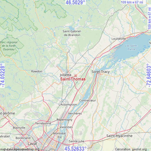
Saint-Thomas GPS coordinates[2]
46° 1' 0.372" North, 73° 20' 56.94" West
| Map corner | latitude | longitude |
|---|---|---|
| Upper-left | 46.5029°, | -74.05228° |
| Center: | 46.01677°, | -73.34915° |
| Lower-right: | 45.52633°, | -72.64603° |
| Map W x H: | 108.6×108.6 km | = 67.5×67.5mi |
| max Lat: | 73.03752° ⇑62.8% North |
| Saint-Thomas: | 46.01677° |
| min Lat: | ⇓37.2% South 42.05009° |
| min Long | Saint-Thomas | max Long |
| -139.43328° | -73.34915° | -52.70931° |
| W 69.9%⇐ | ⇒30.1% E |
Elevation
Elevation of Saint-Thomas is 28 m = 92 ft, and this is 226.4 m = 743 ft below average elevation for this country.
| Max E: |
1518 m = 4980 ft | 82.2% |
| Avg. | 254.4 m = 835 ft | |
| Saint-Thomas | 28 m = 92 ft | |
Min E: |
-2 m = -7 ft | 17.8% |
See also: Canada elevation on elevation.city.
Geographical zone
Saint-Thomas is located in North temperate zone (between Tropic of Cancer and the Arctic Circle). Distance of this North polar circle is 2284.6 km =1419.6 mi to North.| Distance of | km | miles | from Saint-Thomas |
|---|---|---|---|
| North Pole | 4890.5 | 3038.8 | to North |
| Arctic Circle | 2284.6 | 1419.6 | to North |
| Tropic Cancer | 2510.7 | 1560.1 | to South |
| Equator | 5116.6 | 3179.3 | to South |


Nearby cities:
15 places around Saint-Thomas: (largest is in red/bold)
• Berthierville
14.8 km =9.2 mi,  60°
60°
• Contrecoeur
20.6 km =12.8 mi,  154°
154°
• Crabtree
10.6 km =6.6 mi,  238°
238°
• Joliette
5.7 km =3.5 mi,  269°
269°
• L'Épiphanie
21.2 km =13.2 mi,  209°
209°
• Lanoraie
11.7 km =7.3 mi,  118°
118°
• Lavaltrie
15.7 km =9.8 mi,  160°
160°
• Notre-Dame-des-Prairies
7.4 km =4.6 mi,  299°
299°
• Saint-Ambroise
17.3 km =10.7 mi,  292°
292°
• Saint-Félix-de-Valois
18 km =11.2 mi,  340°
340°
• Saint-Jacques
18.7 km =11.6 mi,  246°
246°
• Saint-Joseph
11.9 km =7.4 mi, 123°
• Saint-Norbert
17.2 km =10.7 mi,  8°
8°
• Sainte-Élisabeth
8.7 km =5.4 mi,  358°
358°
• Sorel-Tracy
18.4 km =11.4 mi,  81°
81°
Sources, notices
• [Note1] Compared only with cities in Canada existing in our database
• [Src1] Map data: © OpenStreetMap contributors (CC-BY-SA)
• [Src2] Other city data from geonames.org with taken over terms of usage.
• [Src3] Geographical zone / Annual Mean Temperature by Robert A. Rohde @ Wikipedia
