Saint-Norbert geodata
Saint-Norbert (Quebec) is a populated place; located in Canada in America/Toronto (GMT-4) time zone. With population of 1,059 people, there are 1020 cities with bigger population in this country. Compared to other cities in Canada, 59.8% of cities are located further ↑North; 70.2% of cities are located further ←West and 65% of cities have higher elevation than Saint-Norbert. Note1


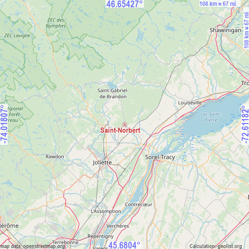
Saint-Norbert GPS coordinates[2]
46° 10' 10.164" North, 73° 18' 53.784" West
| Map corner | latitude | longitude |
|---|---|---|
| Upper-left | 46.65427°, | -74.01807° |
| Center: | 46.16949°, | -73.31494° |
| Lower-right: | 45.6804°, | -72.61182° |
| Map W x H: | 108.3×108.3 km | = 67.3×67.3mi |
| max Lat: | 73.03752° ⇑59.8% North |
| Saint-Norbert: | 46.16949° |
| min Lat: | ⇓40.2% South 42.05009° |
| min Long | Saint-Norbert | max Long |
| -139.43328° | -73.31494° | -52.70931° |
| W 70.2%⇐ | ⇒29.8% E |
Elevation
Elevation of Saint-Norbert is 76 m = 249 ft, and this is 178.4 m = 585 ft below average elevation for this country.
| Max E: |
1518 m = 4980 ft | 65% |
| Avg. | 254.4 m = 835 ft | |
| Saint-Norbert | 76 m = 249 ft | |
Min E: |
-2 m = -7 ft | 35% |
See also: Canada elevation on elevation.city.
Geographical zone
Saint-Norbert is located in North temperate zone (between Tropic of Cancer and the Arctic Circle). Distance of this North polar circle is 2267.6 km =1409 mi to North.| Distance of | km | miles | from Saint-Norbert |
|---|---|---|---|
| North Pole | 4873.5 | 3028.3 | to North |
| Arctic Circle | 2267.6 | 1409 | to North |
| Tropic Cancer | 2527.6 | 1570.6 | to South |
| Equator | 5133.6 | 3189.9 | to South |


Nearby cities:
15 places around Saint-Norbert: (largest is in red/bold)
• Berthierville
14 km =8.7 mi,  133°
133°
• Crabtree
25.4 km =15.8 mi,  207°
207°
• Joliette
19 km =11.8 mi, 206°
• Lanoraie
23.8 km =14.8 mi,  161°
161°
• Mandeville
22.1 km =13.7 mi,  353°
353°
• Maskinongé
23.7 km =14.7 mi,  73°
73°
• Notre-Dame-des-Prairies
16.1 km =10 mi, 214°
• Saint-Ambroise
21.3 km =13.2 mi,  240°
240°
• Saint-Félix-de-Valois
8.5 km =5.3 mi,  270°
270°
• Saint-Gabriel
15.4 km =9.6 mi,  340°
340°
• Saint-Joseph
24.6 km =15.3 mi, 162°
• Saint-Thomas
17.2 km =10.7 mi,  188°
188°
• Sainte-Béatrix
23.4 km =14.5 mi,  278°
278°
• Sainte-Élisabeth
8.8 km =5.5 mi,  198°
198°
• Sorel-Tracy
21 km =13 mi, 132°
Sources, notices
• [Note1] Compared only with cities in Canada existing in our database
• [Src1] Map data: © OpenStreetMap contributors (CC-BY-SA)
• [Src2] Other city data from geonames.org with taken over terms of usage.
• [Src3] Geographical zone / Annual Mean Temperature by Robert A. Rohde @ Wikipedia
