Crabtree geodata
Crabtree (Quebec) is a populated place; located in Canada in America/Toronto (GMT-4) time zone. With population of 2,248 people, there are 708 cities with bigger population in this country. Compared to other cities in Canada, 64.1% of cities are located further ↑North; 68.6% of cities are located further ←West and 77.7% of cities have higher elevation than Crabtree. Note1


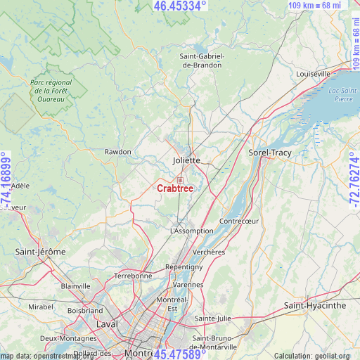
Crabtree GPS coordinates[2]
45° 58' 0.372" North, 73° 27' 57.096" West
| Map corner | latitude | longitude |
|---|---|---|
| Upper-left | 46.45334°, | -74.16899° |
| Center: | 45.96677°, | -73.46586° |
| Lower-right: | 45.47589°, | -72.76274° |
| Map W x H: | 108.7×108.7 km | = 67.5×67.5mi |
| max Lat: | 73.03752° ⇑64.1% North |
| Crabtree: | 45.96677° |
| min Lat: | ⇓35.9% South 42.05009° |
| min Long | Crabtree | max Long |
| -139.43328° | -73.46586° | -52.70931° |
| W 68.6%⇐ | ⇒31.4% E |
Elevation
Elevation of Crabtree is 36 m = 118 ft, and this is 218.4 m = 717 ft below average elevation for this country.
| Max E: |
1518 m = 4980 ft | 77.7% |
| Avg. | 254.4 m = 835 ft | |
| Crabtree | 36 m = 118 ft | |
Min E: |
-2 m = -7 ft | 22.3% |
See also: Canada elevation on elevation.city.
Geographical zone
Crabtree is located in North temperate zone (between Tropic of Cancer and the Arctic Circle). Distance of this North polar circle is 2290.1 km =1423 mi to North.| Distance of | km | miles | from Crabtree |
|---|---|---|---|
| North Pole | 4896 | 3042.2 | to North |
| Arctic Circle | 2290.1 | 1423 | to North |
| Tropic Cancer | 2505.1 | 1556.6 | to South |
| Equator | 5111 | 3175.8 | to South |


Nearby cities:
15 places around Crabtree: (largest is in red/bold)
• Contrecoeur
22.2 km =13.8 mi,  125°
125°
• Joliette
6.4 km =4 mi,  30°
30°
• L'Assomption
16.2 km =10.1 mi,  169°
169°
• L'Épiphanie
13 km =8.1 mi,  185°
185°
• Lanoraie
19.3 km =12 mi,  90°
90°
• Lavaltrie
16.9 km =10.5 mi,  123°
123°
• Notre-Dame-des-Prairies
9.6 km =6 mi,  15°
15°
• Rawdon
21.4 km =13.3 mi,  295°
295°
• Saint-Ambroise
14.1 km =8.8 mi,  330°
330°
• Saint-Jacques
8.3 km =5.2 mi,  255°
255°
• Saint-Joseph
19 km =11.8 mi, 92°
• Saint-Thomas
10.6 km =6.6 mi,  58°
58°
• Sainte-Julienne
19.3 km =12 mi,  270°
270°
• Sainte-Élisabeth
16.8 km =10.4 mi, 31°
• Verchères
22.3 km =13.9 mi,  156°
156°
Sources, notices
• [Note1] Compared only with cities in Canada existing in our database
• [Src1] Map data: © OpenStreetMap contributors (CC-BY-SA)
• [Src2] Other city data from geonames.org with taken over terms of usage.
• [Src3] Geographical zone / Annual Mean Temperature by Robert A. Rohde @ Wikipedia
