Shenley geodata
Shenley (Quebec) is a populated place; located in Canada in America/Toronto (GMT-4) time zone. With population of 882 people, there are 1080 cities with bigger population in this country. Compared to other cities in Canada, 63.3% of cities are located further ↑North; 81.7% of cities are located further ←West and 77.7% of cities have lower elevation than Shenley. Note1


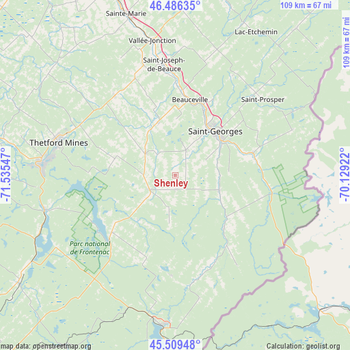
Shenley GPS coordinates[2]
46° 0' 0.252" North, 70° 49' 56.424" West
| Map corner | latitude | longitude |
|---|---|---|
| Upper-left | 46.48635°, | -71.53547° |
| Center: | 46.00007°, | -70.83234° |
| Lower-right: | 45.50948°, | -70.12922° |
| Map W x H: | 108.6×108.6 km | = 67.5×67.5mi |
| max Lat: | 73.03752° ⇑63.3% North |
| Shenley: | 46.00007° |
| min Lat: | ⇓36.7% South 42.05009° |
| min Long | Shenley | max Long |
| -139.43328° | -70.83234° | -52.70931° |
| W 81.7%⇐ | ⇒18.3% E |
Elevation
Elevation of Shenley is 390 m = 1280 ft, and this is 135.6 m = 445 ft above average elevation for this country.
| Max E: |
1518 m = 4980 ft | 22.3% |
| Shenley | 390 m 1280 ft | |
| Avg. | 254.4 m = 835 ft | |
Min E: |
-2 m = -7 ft | 77.7% |
See also: Canada elevation on elevation.city.
Geographical zone
Shenley is located in North temperate zone (between Tropic of Cancer and the Arctic Circle). Distance of this North polar circle is 2286.4 km =1420.7 mi to North.| Distance of | km | miles | from Shenley |
|---|---|---|---|
| North Pole | 4892.3 | 3039.9 | to North |
| Arctic Circle | 2286.4 | 1420.7 | to North |
| Tropic Cancer | 2508.8 | 1558.9 | to South |
| Equator | 5114.7 | 3178.1 | to South |


Nearby cities:
15 places around Shenley: (largest is in red/bold)
• Adstock
20.1 km =12.5 mi,  286°
286°
• Beauceville
24.6 km =15.3 mi,  9°
9°
• Disraeli
41.5 km =25.8 mi,  254°
254°
• East Broughton
30.3 km =18.8 mi,  321°
321°
• Lac-Mégantic
46.5 km =28.9 mi,  184°
184°
• Linière
32.2 km =20 mi,  90°
90°
• Saint-Côme--Linière
25.5 km =15.8 mi,  73°
73°
• Saint-Georges
18 km =11.2 mi,  45°
45°
• Saint-Joseph-de-Beauce
33.5 km =20.8 mi,  355°
355°
• Saint-Joseph-de-Coleraine
41.4 km =25.7 mi,  264°
264°
• Saint-Théophile
28 km =17.4 mi,  105°
105°
• Saint-Éphrem-de-Beauce
11.7 km =7.3 mi,  309°
309°
• Sainte-Marie
50.2 km =31.2 mi,  344°
344°
• Thetford-Mines
38 km =23.6 mi, 285°
• Vallée-Jonction
42.2 km =26.2 mi,  350°
350°
Sources, notices
• [Note1] Compared only with cities in Canada existing in our database
• [Src1] Map data: © OpenStreetMap contributors (CC-BY-SA)
• [Src2] Other city data from geonames.org with taken over terms of usage.
• [Src3] Geographical zone / Annual Mean Temperature by Robert A. Rohde @ Wikipedia
