Saint-Georges geodata
Saint-Georges (Quebec) is a populated place; located in Canada in America/Toronto (GMT-4) time zone. With population of 31,173 people, there are 143 cities with bigger population in this country. Compared to other cities in Canada, 60.6% of cities are located further ↑North; 81.9% of cities are located further ←West and 51.3% of cities have higher elevation than Saint-Georges. Note1


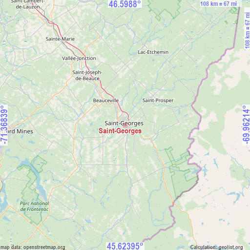
Saint-Georges GPS coordinates[2]
46° 6' 48.708" North, 70° 39' 54.936" West
| Map corner | latitude | longitude |
|---|---|---|
| Upper-left | 46.5988°, | -71.36839° |
| Center: | 46.11353°, | -70.66526° |
| Lower-right: | 45.62395°, | -69.96214° |
| Map W x H: | 108.4×108.4 km | = 67.4×67.4mi |
| max Lat: | 73.03752° ⇑60.6% North |
| Saint-Georges: | 46.11353° |
| min Lat: | ⇓39.4% South 42.05009° |
| min Long | Saint-Georges | max Long |
| -139.43328° | -70.66526° | -52.70931° |
| W 81.9%⇐ | ⇒18.1% E |
Elevation
Elevation of Saint-Georges is 163 m = 535 ft, and this is 91.4 m = 300 ft below average elevation for this country.
| Max E: |
1518 m = 4980 ft | 51.3% |
| Avg. | 254.4 m = 835 ft | |
| Saint-Georges | 163 m = 535 ft | |
Min E: |
-2 m = -7 ft | 48.7% |
See also: Canada elevation on elevation.city.
Geographical zone
Saint-Georges is located in North temperate zone (between Tropic of Cancer and the Arctic Circle). Distance of this North polar circle is 2273.8 km =1412.9 mi to North.| Distance of | km | miles | from Saint-Georges |
|---|---|---|---|
| North Pole | 4879.7 | 3032.1 | to North |
| Arctic Circle | 2273.8 | 1412.9 | to North |
| Tropic Cancer | 2521.4 | 1566.7 | to South |
| Equator | 5127.3 | 3186 | to South |


Nearby cities:
15 places around Saint-Georges: (largest is in red/bold)
• Adstock
32.9 km =20.4 mi,  257°
257°
• Beauceville
14.5 km =9 mi,  323°
323°
• Disraeli
57.9 km =36 mi,  245°
245°
• East Broughton
33.6 km =20.9 mi,  289°
289°
• Lac-Mégantic
61.3 km =38.1 mi,  195°
195°
• Linière
23 km =14.3 mi,  123°
123°
• Saint-Côme--Linière
12.6 km =7.8 mi,  114°
114°
• Saint-Joseph-de-Beauce
25.9 km =16.1 mi, 323°
• Saint-Joseph-de-Coleraine
56.5 km =35.1 mi, 253°
• Saint-Théophile
24.5 km =15.2 mi,  144°
144°
• Saint-Éphrem-de-Beauce
22.5 km =14 mi, 256°
• Sainte-Marie
44.5 km =27.7 mi, 323°
• Shenley
18 km =11.2 mi,  225°
225°
• Thetford-Mines
49.4 km =30.7 mi,  267°
267°
• Vallée-Jonction
35 km =21.7 mi,  326°
326°
Sources, notices
• [Note1] Compared only with cities in Canada existing in our database
• [Src1] Map data: © OpenStreetMap contributors (CC-BY-SA)
• [Src2] Other city data from geonames.org with taken over terms of usage.
• [Src3] Geographical zone / Annual Mean Temperature by Robert A. Rohde @ Wikipedia
