Smithers geodata
Smithers (British Columbia) is a populated place; located in Canada in America/Vancouver (GMT-7) time zone. With population of 5,438 people, there are 455 cities with bigger population in this country. Compared to other cities in Canada, 95% of cities are located further ↓South; 98.7% of cities are located further →East and 81.4% of cities have lower elevation than Smithers. Note1
Administrative division(s):
- Level 1: British Columbia
- Level 2: Regional District of Bulkley-Nechako
- Level 3: Smithers


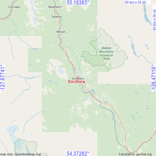
Smithers GPS coordinates[2]
54° 46' 49.296" North, 127° 10' 27.408" West
| Map corner | latitude | longitude |
|---|---|---|
| Upper-left | 55.18383°, | -127.87741° |
| Center: | 54.78036°, | -127.17428° |
| Lower-right: | 54.37282°, | -126.47116° |
| Map W x H: | 90.2×90.2 km | = 56×56mi |
| max Lat: | 73.03752° ⇑5% North |
| Smithers: | 54.78036° |
| min Lat: | ⇓95% South 42.05009° |
| min Long | Smithers | max Long |
| -139.43328° | -127.17428° | -52.70931° |
| W 1.3%⇐ | ⇒98.7% E |
Elevation
Elevation of Smithers is 494 m = 1621 ft, and this is 239.6 m = 786 ft above average elevation for this country.
| Max E: |
1518 m = 4980 ft | 18.6% |
| Smithers | 494 m 1621 ft | |
| Avg. | 254.4 m = 835 ft | |
Min E: |
-2 m = -7 ft | 81.4% |
See also: Canada elevation on elevation.city.
Geographical zone
Smithers is located in North temperate zone (between Tropic of Cancer and the Arctic Circle). Distance of this North polar circle is 1310.2 km =814.1 mi to North.| Distance of | km | miles | from Smithers |
|---|---|---|---|
| North Pole | 3916.1 | 2433.4 | to North |
| Arctic Circle | 1310.2 | 814.1 | to North |
| Tropic Cancer | 3485.1 | 2165.5 | to South |
| Equator | 6091 | 3784.8 | to South |


Nearby cities:
7 places around Smithers: (largest is in red/bold)
• Burns Lake
109.9 km =68.3 mi,  123°
123°
• Houston
53.3 km =33.1 mi,  142°
142°
• Kitimat
125.3 km =77.9 mi,  229°
229°
• New Hazelton
58.3 km =36.2 mi,  332°
332°
• Prince Rupert
209.4 km =130.1 mi,  255°
255°
• Terrace
96.5 km =60 mi,  252°
252°
• Vanderhoof
221.1 km =137.4 mi,  112°
112°
Sources, notices
• [Note1] Compared only with cities in Canada existing in our database
• [Src1] Map data: © OpenStreetMap contributors (CC-BY-SA)
• [Src2] Other city data from geonames.org with taken over terms of usage.
• [Src3] Geographical zone / Annual Mean Temperature by Robert A. Rohde @ Wikipedia
