Vanderhoof geodata
Vanderhoof (British Columbia) is a populated place; located in Canada in America/Vancouver (GMT-7) time zone. With population of 1,462 people, there are 874 cities with bigger population in this country. Compared to other cities in Canada, 93.3% of cities are located further ↓South; 96.5% of cities are located further →East and 88.5% of cities have lower elevation than Vanderhoof. Note1
Administrative division(s):
- Level 1: British Columbia
- Level 2: Regional District of Bulkley-Nechako
- Level 3: Vanderhoof


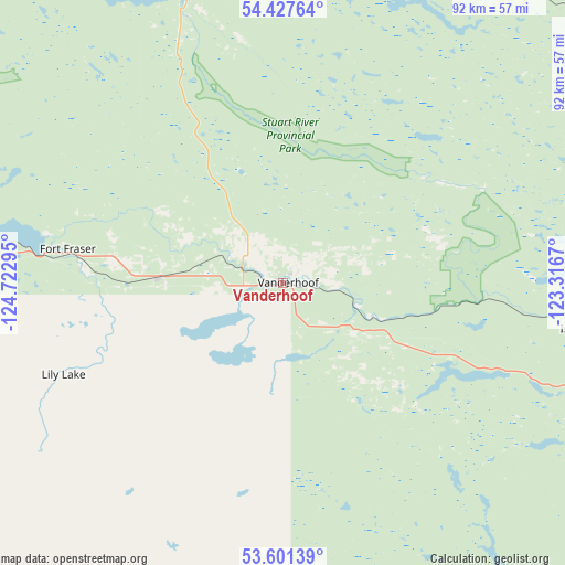
Vanderhoof GPS coordinates[2]
54° 0' 59.652" North, 124° 1' 11.352" West
| Map corner | latitude | longitude |
|---|---|---|
| Upper-left | 54.42764°, | -124.72295° |
| Center: | 54.01657°, | -124.01982° |
| Lower-right: | 53.60139°, | -123.3167° |
| Map W x H: | 91.9×91.9 km | = 57.1×57.1mi |
| max Lat: | 73.03752° ⇑6.7% North |
| Vanderhoof: | 54.01657° |
| min Lat: | ⇓93.3% South 42.05009° |
| min Long | Vanderhoof | max Long |
| -139.43328° | -124.01982° | -52.70931° |
| W 3.5%⇐ | ⇒96.5% E |
Elevation
Elevation of Vanderhoof is 635 m = 2083 ft, and this is 380.6 m = 1249 ft above average elevation for this country.
| Max E: |
1518 m = 4980 ft | 11.5% |
| Vanderhoof | 635 m 2083 ft | |
| Avg. | 254.4 m = 835 ft | |
Min E: |
-2 m = -7 ft | 88.5% |
See also: Canada elevation on elevation.city.
Geographical zone
Vanderhoof is located in North temperate zone (between Tropic of Cancer and the Arctic Circle). Distance of this North polar circle is 1395.1 km =866.9 mi to North.| Distance of | km | miles | from Vanderhoof |
|---|---|---|---|
| North Pole | 4001 | 2486.1 | to North |
| Arctic Circle | 1395.1 | 866.9 | to North |
| Tropic Cancer | 3400.2 | 2112.8 | to South |
| Equator | 6006.1 | 3732 | to South |


Nearby cities:
15 places around Vanderhoof: (largest is in red/bold)
• Burns Lake
115.9 km =72 mi,  281°
281°
• Chetwynd
241.4 km =150 mi,  39°
39°
• Clinton
365.3 km =227 mi,  153°
153°
• Fort St. John
319.6 km =198.6 mi, 39°
• Fox Mountain
244 km =151.6 mi, 148°
• Grand Haven
316.3 km =196.5 mi, 38°
• Hanceville
242.2 km =150.5 mi,  164°
164°
• Houston
177.5 km =110.3 mi, 283°
• Mackenzie
158.4 km =98.4 mi,  22°
22°
• New Hazelton
267.5 km =166.2 mi,  300°
300°
• Prince George
83.6 km =51.9 mi,  97°
97°
• Quesnel
153.4 km =95.3 mi,  138°
138°
• Smithers
221.1 km =137.4 mi,  292°
292°
• Tumbler Ridge
231 km =143.5 mi,  57°
57°
• Williams Lake
243.2 km =151.1 mi, 149°
Sources, notices
• [Note1] Compared only with cities in Canada existing in our database
• [Src1] Map data: © OpenStreetMap contributors (CC-BY-SA)
• [Src2] Other city data from geonames.org with taken over terms of usage.
• [Src3] Geographical zone / Annual Mean Temperature by Robert A. Rohde @ Wikipedia
