St. Albert geodata
St. Albert (Alberta) is a populated place; located in Canada in America/Edmonton (GMT-6) time zone. With population of 57,719 people, there are 92 cities with bigger population in this country. Compared to other cities in Canada, 92.2% of cities are located further ↓South; 80.1% of cities are located further →East and 89.8% of cities have lower elevation than St. Albert. Note1


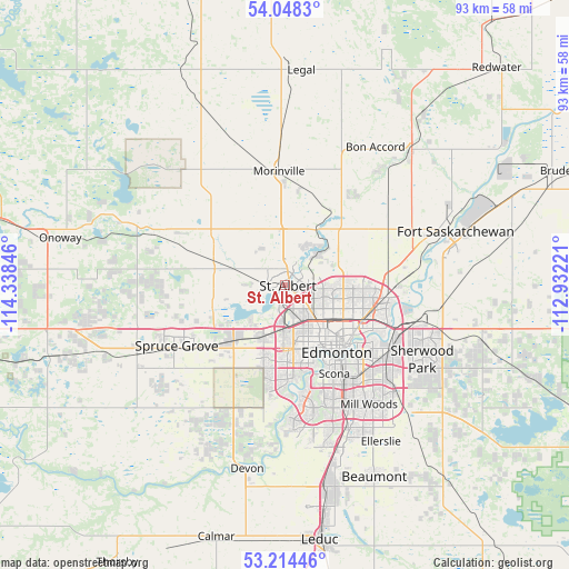
St. Albert GPS coordinates[2]
53° 38' 0.384" North, 113° 38' 7.188" West
| Map corner | latitude | longitude |
|---|---|---|
| Upper-left | 54.0483°, | -114.33846° |
| Center: | 53.63344°, | -113.63533° |
| Lower-right: | 53.21446°, | -112.93221° |
| Map W x H: | 92.7×92.7 km | = 57.6×57.6mi |
| max Lat: | 73.03752° ⇑7.8% North |
| St. Albert: | 53.63344° |
| min Lat: | ⇓92.2% South 42.05009° |
| min Long | St. Albert | max Long |
| -139.43328° | -113.63533° | -52.70931° |
| W 19.9%⇐ | ⇒80.1% E |
Elevation
Elevation of St. Albert is 663 m = 2175 ft, and this is 408.6 m = 1341 ft above average elevation for this country.
| Max E: |
1518 m = 4980 ft | 10.2% |
| St. Albert | 663 m 2175 ft | |
| Avg. | 254.4 m = 835 ft | |
Min E: |
-2 m = -7 ft | 89.8% |
See also: St. Albert elevation on elevation.city.
Geographical zone
St. Albert is located in North temperate zone (between Tropic of Cancer and the Arctic Circle). Distance of this North polar circle is 1437.7 km =893.3 mi to North.| Distance of | km | miles | from St. Albert |
|---|---|---|---|
| North Pole | 4043.6 | 2512.6 | to North |
| Arctic Circle | 1437.7 | 893.3 | to North |
| Tropic Cancer | 3357.6 | 2086.3 | to South |
| Equator | 5963.5 | 3705.5 | to South |


Nearby cities:
15 places around St. Albert: (largest is in red/bold)
• Bon Accord
26.4 km =16.4 mi,  32°
32°
• Edmonton
14.4 km =8.9 mi,  130°
130°
• Fort Saskatchewan
29 km =18 mi,  71°
71°
• Larkspur
24 km =14.9 mi,  135°
135°
• Laurel
26.7 km =16.6 mi, 141°
• Maple Ridge
23.2 km =14.4 mi, 129°
• Mill Woods Town Centre
24 km =14.9 mi,  145°
145°
• Morinville
18.6 km =11.6 mi,  356°
356°
• Rideau Park
19.2 km =11.9 mi, 153°
• Sherwood Park
24.6 km =15.3 mi,  121°
121°
• Silver Berry
25.7 km =16 mi, 139°
• Spruce Grove
21.8 km =13.5 mi,  239°
239°
• Stony Plain
26.6 km =16.5 mi,  245°
245°
• Tamarack
26 km =16.2 mi, 136°
• Wild Rose
24.7 km =15.3 mi, 137°
In other languages:
- In Spanish: Saint Albert
- In France: Saint-Albert
- In Italian: Saint Albert
- In Chinese: 圣艾伯特
Sources, notices
• [Note1] Compared only with cities in Canada existing in our database
• [Src1] Map data: © OpenStreetMap contributors (CC-BY-SA)
• [Src2] Other city data from geonames.org with taken over terms of usage.
• [Src3] Geographical zone / Annual Mean Temperature by Robert A. Rohde @ Wikipedia
