Edmonton geodata
Edmonton (Alberta) is a seat of a first-order administrative division; located in Canada in America/Edmonton (GMT-6) time zone. With population of 712,391 people, there are 4 cities with bigger population in this country. Compared to other cities in Canada, 92% of cities are located further ↓South; 79.5% of cities are located further →East and 87.3% of cities have lower elevation than Edmonton. Note1


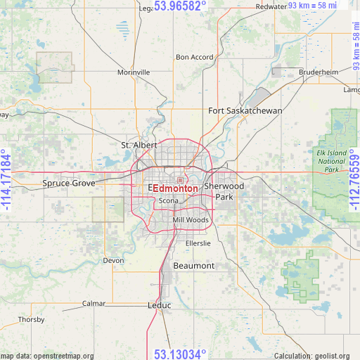
Edmonton GPS coordinates[2]
53° 33' 0.504" North, 113° 28' 7.356" West
| Map corner | latitude | longitude |
|---|---|---|
| Upper-left | 53.96582°, | -114.17184° |
| Center: | 53.55014°, | -113.46871° |
| Lower-right: | 53.13034°, | -112.76559° |
| Map W x H: | 92.9×92.9 km | = 57.7×57.7mi |
| max Lat: | 73.03752° ⇑8% North |
| Edmonton: | 53.55014° |
| min Lat: | ⇓92% South 42.05009° |
| min Long | Edmonton | max Long |
| -139.43328° | -113.46871° | -52.70931° |
| W 20.5%⇐ | ⇒79.5% E |
Elevation
Elevation of Edmonton is 610 m = 2001 ft, and this is 355.6 m = 1167 ft above average elevation for this country.
| Max E: |
1518 m = 4980 ft | 12.7% |
| Edmonton | 610 m 2001 ft | |
| Avg. | 254.4 m = 835 ft | |
Min E: |
-2 m = -7 ft | 87.3% |
See also: Edmonton elevation on elevation.city.
Geographical zone
Edmonton is located in North temperate zone (between Tropic of Cancer and the Arctic Circle). Distance of this North polar circle is 1447 km =899.1 mi to North.| Distance of | km | miles | from Edmonton |
|---|---|---|---|
| North Pole | 4052.8 | 2518.3 | to North |
| Arctic Circle | 1447 | 899.1 | to North |
| Tropic Cancer | 3348.3 | 2080.5 | to South |
| Equator | 5954.2 | 3699.8 | to South |


Nearby cities:
15 places around Edmonton: (largest is in red/bold)
• Beaumont
22.5 km =14 mi,  171°
171°
• Devon
27 km =16.8 mi,  220°
220°
• Fort Saskatchewan
24.8 km =15.4 mi,  41°
41°
• Larkspur
9.8 km =6.1 mi,  143°
143°
• Laurel
12.9 km =8 mi,  153°
153°
• Maple Ridge
8.8 km =5.5 mi,  127°
127°
• Mill Woods Town Centre
10.8 km =6.7 mi, 165°
• Morinville
30.3 km =18.8 mi,  336°
336°
• Rideau Park
8.3 km =5.2 mi,  196°
196°
• Sherwood Park
10.6 km =6.6 mi,  110°
110°
• Silver Berry
11.8 km =7.3 mi, 150°
• Spruce Grove
29.8 km =18.5 mi,  266°
266°
• St. Albert
14.4 km =8.9 mi,  310°
310°
• Tamarack
11.8 km =7.3 mi, 143°
• Wild Rose
10.6 km =6.6 mi, 146°
Sources, notices
• [Note1] Compared only with cities in Canada existing in our database
• [Src1] Map data: © OpenStreetMap contributors (CC-BY-SA)
• [Src2] Other city data from geonames.org with taken over terms of usage.
• [Src3] Geographical zone / Annual Mean Temperature by Robert A. Rohde @ Wikipedia
