Edmundston geodata
Edmundston (New Brunswick) is a populated place; located in Canada in America/Moncton (GMT-3) time zone. With population of 16,643 people, there are 221 cities with bigger population in this country. Compared to other cities in Canada, 50.3% of cities are located further ↑North; 84.8% of cities are located further ←West and 53.1% of cities have higher elevation than Edmundston. Note1


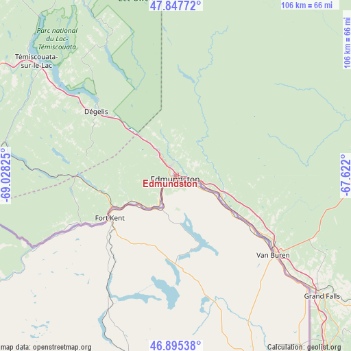
Edmundston GPS coordinates[2]
47° 22' 25.32" North, 68° 19' 30.432" West
| Map corner | latitude | longitude |
|---|---|---|
| Upper-left | 47.84772°, | -69.02825° |
| Center: | 47.3737°, | -68.32512° |
| Lower-right: | 46.89538°, | -67.622° |
| Map W x H: | 105.9×105.9 km | = 65.8×65.8mi |
| max Lat: | 73.03752° ⇑50.3% North |
| Edmundston: | 47.3737° |
| min Lat: | ⇓49.7% South 42.05009° |
| min Long | Edmundston | max Long |
| -139.43328° | -68.32512° | -52.70931° |
| W 84.8%⇐ | ⇒15.2% E |
Elevation
Elevation of Edmundston is 154 m = 505 ft, and this is 100.4 m = 329 ft below average elevation for this country.
| Max E: |
1518 m = 4980 ft | 53.1% |
| Avg. | 254.4 m = 835 ft | |
| Edmundston | 154 m = 505 ft | |
Min E: |
-2 m = -7 ft | 46.9% |
See also: Canada elevation on elevation.city.
Geographical zone
Edmundston is located in North temperate zone (between Tropic of Cancer and the Arctic Circle). Distance of this North polar circle is 2133.7 km =1325.8 mi to North.| Distance of | km | miles | from Edmundston |
|---|---|---|---|
| North Pole | 4739.6 | 2945 | to North |
| Arctic Circle | 2133.7 | 1325.8 | to North |
| Tropic Cancer | 2661.5 | 1653.8 | to South |
| Equator | 5267.5 | 3273.1 | to South |


Nearby cities:
15 places around Edmundston: (largest is in red/bold)
• Cabano
53.7 km =33.4 mi,  309°
309°
• Cacouna
106.8 km =66.4 mi,  304°
304°
• Clair
25 km =15.5 mi,  237°
237°
• Florenceville-Bristol
116.6 km =72.5 mi,  152°
152°
• Harrison Brook
34.8 km =21.6 mi,  120°
120°
• Lac-des-Aigles
73.5 km =45.7 mi,  338°
338°
• Le Bic
114.7 km =71.3 mi,  346°
346°
• Pohénégamook
68.6 km =42.6 mi,  278°
278°
• Rivière-du-Loup
104.3 km =64.8 mi, 298°
• Saint-André
110.2 km =68.5 mi,  287°
287°
• Saint-Antonin
96.6 km =60 mi, 296°
• Saint-Basile
4.5 km =2.8 mi,  64°
64°
• Saint-Léonard
38.2 km =23.7 mi,  127°
127°
• Saint-Mathieu-de-Rioux
102.7 km =63.8 mi,  331°
331°
• Saint-Pascal
112.3 km =69.8 mi, 278°
Sources, notices
• [Note1] Compared only with cities in Canada existing in our database
• [Src1] Map data: © OpenStreetMap contributors (CC-BY-SA)
• [Src2] Other city data from geonames.org with taken over terms of usage.
• [Src3] Geographical zone / Annual Mean Temperature by Robert A. Rohde @ Wikipedia
