Saint-Mathieu-de-Rioux geodata
Saint-Mathieu-de-Rioux (Quebec) is a populated place; located in Canada in America/Toronto (GMT-4) time zone. With population of 672 people, there are 1126 cities with bigger population in this country. Compared to other cities in Canada, 55.4% of cities are located further ↓South; 83.9% of cities are located further ←West and 54% of cities have higher elevation than Saint-Mathieu-de-Rioux. Note1
Administrative division(s):
- Level 1: Quebec
- Level 2: Bas-Saint-Laurent
- Level 3: Saint-Mathieu-de-Rioux


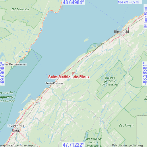
Saint-Mathieu-de-Rioux GPS coordinates[2]
48° 10' 59.412" North, 68° 59' 12.948" West
| Map corner | latitude | longitude |
|---|---|---|
| Upper-left | 48.64984°, | -69.69006° |
| Center: | 48.18317°, | -68.98693° |
| Lower-right: | 47.71222°, | -68.28381° |
| Map W x H: | 104.3×104.3 km | = 64.8×64.8mi |
| max Lat: | 73.03752° ⇑44.6% North |
| Saint-Mathieu-de-Rioux: | 48.18317° |
| min Lat: | ⇓55.4% South 42.05009° |
| min Long | Saint-Mathieu-d | max Long |
| -139.43328° | -68.98693° | -52.70931° |
| W 83.9%⇐ | ⇒16.1% E |
Elevation
Elevation of Saint-Mathieu-de-Rioux is 148 m = 486 ft, and this is 106.4 m = 349 ft below average elevation for this country.
| Max E: |
1518 m = 4980 ft | 54% |
| Avg. | 254.4 m = 835 ft | |
| Saint-Mathieu-de-Rioux | 148 m = 486 ft | |
Min E: |
-2 m = -7 ft | 46% |
See also: Canada elevation on elevation.city.
Geographical zone
Saint-Mathieu-de-Rioux is located in North temperate zone (between Tropic of Cancer and the Arctic Circle). Distance of this North polar circle is 2043.7 km =1269.9 mi to North.| Distance of | km | miles | from Saint-Mathieu-de-Rioux |
|---|---|---|---|
| North Pole | 4649.6 | 2889.1 | to North |
| Arctic Circle | 2043.7 | 1269.9 | to North |
| Tropic Cancer | 2751.5 | 1709.7 | to South |
| Equator | 5357.5 | 3329 | to South |


Nearby cities:
15 places around Saint-Mathieu-de-Rioux: (largest is in red/bold)
• Cabano
56.5 km =35.1 mi,  171°
171°
• Cacouna
48.3 km =30 mi,  232°
232°
• Forestville
62.1 km =38.6 mi,  353°
353°
• Lac-des-Aigles
31.4 km =19.5 mi,  133°
133°
• Le Bic
30.4 km =18.9 mi,  45°
45°
• Les Escoumins
36.3 km =22.6 mi,  301°
301°
• Luceville
59.3 km =36.8 mi, 47°
• Mont-Joli
73.7 km =45.8 mi, 52°
• Rimouski
45.2 km =28.1 mi, 49°
• Rivière-du-Loup
57.2 km =35.5 mi, 226°
• Sacré-Coeur
60.5 km =37.6 mi,  274°
274°
• Saint-André
78.4 km =48.7 mi,  224°
224°
• Saint-Antonin
59.5 km =37 mi, 217°
• Saint-Siméon
76.3 km =47.4 mi,  240°
240°
• Tadoussac
54.2 km =33.7 mi, 266°
Sources, notices
• [Note1] Compared only with cities in Canada existing in our database
• [Src1] Map data: © OpenStreetMap contributors (CC-BY-SA)
• [Src2] Other city data from geonames.org with taken over terms of usage.
• [Src3] Geographical zone / Annual Mean Temperature by Robert A. Rohde @ Wikipedia
