Le Bic geodata
Le Bic (Quebec) is a populated place; located in Canada in America/Toronto (GMT-4) time zone. With population of 1,115 people, there are 993 cities with bigger population in this country. Compared to other cities in Canada, 56.1% of cities are located further ↓South; 84.1% of cities are located further ←West and 58.5% of cities have higher elevation than Le Bic. Note1


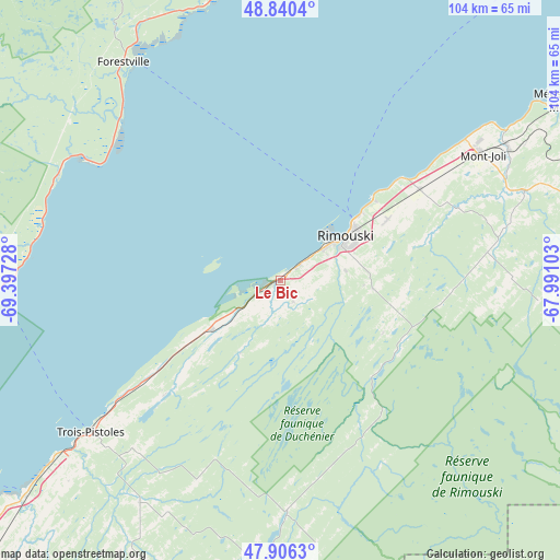
Le Bic GPS coordinates[2]
48° 22' 31.764" North, 68° 41' 38.94" West
| Map corner | latitude | longitude |
|---|---|---|
| Upper-left | 48.8404°, | -69.39728° |
| Center: | 48.37549°, | -68.69415° |
| Lower-right: | 47.9063°, | -67.99103° |
| Map W x H: | 103.9×103.9 km | = 64.6×64.6mi |
| max Lat: | 73.03752° ⇑43.9% North |
| Le Bic: | 48.37549° |
| min Lat: | ⇓56.1% South 42.05009° |
| min Long | Le Bic | max Long |
| -139.43328° | -68.69415° | -52.70931° |
| W 84.1%⇐ | ⇒15.9% E |
Elevation
Elevation of Le Bic is 110 m = 361 ft, and this is 144.4 m = 474 ft below average elevation for this country.
| Max E: |
1518 m = 4980 ft | 58.5% |
| Avg. | 254.4 m = 835 ft | |
| Le Bic | 110 m = 361 ft | |
Min E: |
-2 m = -7 ft | 41.5% |
See also: Canada elevation on elevation.city.
Geographical zone
Le Bic is located in North temperate zone (between Tropic of Cancer and the Arctic Circle). Distance of this North polar circle is 2022.3 km =1256.6 mi to North.| Distance of | km | miles | from Le Bic |
|---|---|---|---|
| North Pole | 4628.2 | 2875.8 | to North |
| Arctic Circle | 2022.3 | 1256.6 | to North |
| Tropic Cancer | 2772.9 | 1723 | to South |
| Equator | 5378.9 | 3342.3 | to South |


Nearby cities:
15 places around Le Bic: (largest is in red/bold)
• Amqui
93.7 km =58.2 mi,  83°
83°
• Cabano
78.5 km =48.8 mi,  190°
190°
• Cacouna
78.6 km =48.8 mi,  229°
229°
• Chute-aux-Outardes
85.2 km =52.9 mi,  14°
14°
• Forestville
49.5 km =30.8 mi,  324°
324°
• Lac-des-Aigles
42.8 km =26.6 mi,  178°
178°
• Les Escoumins
52.7 km =32.7 mi,  267°
267°
• Luceville
28.9 km =18 mi,  49°
49°
• Mont-Joli
43.7 km =27.2 mi,  57°
57°
• Rimouski
15 km =9.3 mi, 57°
• Rivière-du-Loup
87.7 km =54.5 mi, 225°
• Sacré-Coeur
83.4 km =51.8 mi,  258°
258°
• Saint-Antonin
89.8 km =55.8 mi,  220°
220°
• Saint-Mathieu-de-Rioux
30.4 km =18.9 mi, 225°
• Tadoussac
79.7 km =49.5 mi,  251°
251°
Sources, notices
• [Note1] Compared only with cities in Canada existing in our database
• [Src1] Map data: © OpenStreetMap contributors (CC-BY-SA)
• [Src2] Other city data from geonames.org with taken over terms of usage.
• [Src3] Geographical zone / Annual Mean Temperature by Robert A. Rohde @ Wikipedia
