Pohénégamook geodata
Pohénégamook (Quebec) is a populated place; located in Canada in America/Toronto (GMT-4) time zone. With population of 2,770 people, there are 643 cities with bigger population in this country. Compared to other cities in Canada, 50.4% of cities are located further ↓South; 83.8% of cities are located further ←West and 59.7% of cities have lower elevation than Pohénégamook. Note1


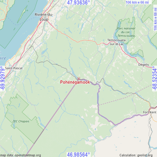
Pohénégamook GPS coordinates[2]
47° 27' 47.34" North, 69° 13' 35.976" West
| Map corner | latitude | longitude |
|---|---|---|
| Upper-left | 47.93636°, | -69.92979° |
| Center: | 47.46315°, | -69.22666° |
| Lower-right: | 46.98564°, | -68.52354° |
| Map W x H: | 105.7×105.7 km | = 65.7×65.7mi |
| max Lat: | 73.03752° ⇑49.6% North |
| Pohénégamook: | 47.46315° |
| min Lat: | ⇓50.4% South 42.05009° |
| min Long | Pohénégamook | max Long |
| -139.43328° | -69.22666° | -52.70931° |
| W 83.8%⇐ | ⇒16.2% E |
Elevation
Elevation of Pohénégamook is 231 m = 758 ft, and this is 23.4 m = 77 ft below average elevation for this country.
| Max E: |
1518 m = 4980 ft | 40.3% |
| Avg. | 254.4 m = 835 ft | |
| Pohénégamook | 231 m = 758 ft | |
Min E: |
-2 m = -7 ft | 59.7% |
See also: Canada elevation on elevation.city.
Geographical zone
Pohénégamook is located in North temperate zone (between Tropic of Cancer and the Arctic Circle). Distance of this North polar circle is 2123.8 km =1319.7 mi to North.| Distance of | km | miles | from Pohénégamook |
|---|---|---|---|
| North Pole | 4729.7 | 2938.9 | to North |
| Arctic Circle | 2123.8 | 1319.7 | to North |
| Tropic Cancer | 2671.5 | 1660 | to South |
| Equator | 5277.4 | 3279.2 | to South |


Nearby cities:
15 places around Pohénégamook: (largest is in red/bold)
• Cabano
35.6 km =22.1 mi,  47°
47°
• Cacouna
54.4 km =33.8 mi,  337°
337°
• Clair
52.2 km =32.4 mi,  116°
116°
• Edmundston
68.6 km =42.6 mi,  98°
98°
• Kamouraska
49.4 km =30.7 mi,  283°
283°
• La Malbaie
72.7 km =45.2 mi,  286°
286°
• La Pocatière
61.7 km =38.3 mi,  260°
260°
• Lac-des-Aigles
71.6 km =44.5 mi,  35°
35°
• Rivière-du-Loup
46.9 km =29.1 mi,  329°
329°
• Saint-André
44.2 km =27.5 mi,  302°
302°
• Saint-Antonin
38.1 km =23.7 mi, 330°
• Saint-Basile
72.3 km =44.9 mi, 96°
• Saint-Pacôme
54.8 km =34.1 mi, 263°
• Saint-Pascal
43.7 km =27.2 mi, 278°
• Saint-Siméon
64.6 km =40.1 mi,  310°
310°
Sources, notices
• [Note1] Compared only with cities in Canada existing in our database
• [Src1] Map data: © OpenStreetMap contributors (CC-BY-SA)
• [Src2] Other city data from geonames.org with taken over terms of usage.
• [Src3] Geographical zone / Annual Mean Temperature by Robert A. Rohde @ Wikipedia
