Sainte Catherine de la Jacques Cartier geodata
Sainte Catherine de la Jacques Cartier (Quebec) is a populated place; located in Canada in America/Toronto (GMT-4) time zone. With population of 5,021 people, there are 474 cities with bigger population in this country. Compared to other cities in Canada, 52.4% of cities are located further ↑North; 78.8% of cities are located further ←West and 52.2% of cities have higher elevation than Sainte Catherine de la Jacques Cartier. Note1
Administrative division(s):
- Level 1: Quebec
- Level 2: Capitale-Nationale
- Level 3: Sainte-Catherine-de-la-Jacques-Cartier
Current local time in Sainte Catherine de la Jacques Cartier:
12:22 PM, WednesdayDifference from your time zone: hours


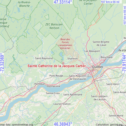
Sainte Catherine de la Jacques Cartier GPS coordinates[2]
46° 51' 8.784" North, 71° 37' 14.016" West
| Map corner | latitude | longitude |
|---|---|---|
| Upper-left | 47.33114°, | -72.32369° |
| Center: | 46.85244°, | -71.62056° |
| Lower-right: | 46.36943°, | -70.91744° |
| Map W x H: | 106.9×106.9 km | = 66.4×66.4mi |
| max Lat: | 73.03752° ⇑52.4% North |
| Sainte Catherine de la Jacques Cartier: | 46.85244° |
| min Lat: | ⇓47.6% South 42.05009° |
| min Long | Sainte Catherin | max Long |
| -139.43328° | -71.62056° | -52.70931° |
| W 78.8%⇐ | ⇒21.2% E |
Elevation
Elevation of Sainte Catherine de la Jacques Cartier is 159 m = 522 ft, and this is 95.4 m = 313 ft below average elevation for this country.
| Max E: |
1518 m = 4980 ft | 52.2% |
| Avg. | 254.4 m = 835 ft | |
| Sainte Catherine de la Jacques Cartier | 159 m = 522 ft | |
Min E: |
-2 m = -7 ft | 47.8% |
See also: Canada elevation on elevation.city.
Geographical zone
Sainte Catherine de la Jacques Cartier is located in North temperate zone (between Tropic of Cancer and the Arctic Circle). Distance of this North polar circle is 2191.7 km =1361.9 mi to North.| Distance of | km | miles | from Sainte Catherine de la Jacques Cartier |
|---|---|---|---|
| North Pole | 4797.6 | 2981.1 | to North |
| Arctic Circle | 2191.7 | 1361.9 | to North |
| Tropic Cancer | 2603.6 | 1617.8 | to South |
| Equator | 5209.5 | 3237 | to South |


Nearby cities:
15 places around Sainte Catherine de la Jacques Cartier: (largest is in red/bold)
• Breakeyville
35.8 km =22.2 mi,  122°
122°
• Cap-Santé
23.8 km =14.8 mi,  212°
212°
• Donnacona
20.7 km =12.9 mi,  202°
202°
• Fossambault-sur-le-Lac
2.7 km =1.7 mi,  8°
8°
• L'Ancienne-Lorette
21.5 km =13.4 mi,  107°
107°
• La Haute-Saint-Charles
19.3 km =12 mi,  77°
77°
• Lotbinière
35.4 km =22 mi,  222°
222°
• Lévis
34.1 km =21.2 mi,  99°
99°
• Neuville
17.4 km =10.8 mi,  170°
170°
• Pont-Rouge
12.3 km =7.6 mi, 207°
• Portneuf
27.3 km =17 mi,  228°
228°
• Québec
31.2 km =19.4 mi, 98°
• Saint-Antoine-de-Tilly
21.3 km =13.2 mi, 170°
• Saint-Augustin-de-Desmaures
17.9 km =11.1 mi,  133°
133°
• Shannon
8.6 km =5.3 mi,  68°
68°
Sources, notices
• [Note1] Compared only with cities in Canada existing in our database
• [Src1] Map data: © OpenStreetMap contributors (CC-BY-SA)
• [Src2] Other city data from geonames.org with taken over terms of usage.
• [Src3] Geographical zone / Annual Mean Temperature by Robert A. Rohde @ Wikipedia
