Québec geodata
Québec (Quebec) is a seat of a first-order administrative division; located in Canada in America/Toronto (GMT-4) time zone. With population of 528,595 people, there are 10 cities with bigger population in this country. Compared to other cities in Canada, 52.6% of cities are located further ↑North; 80.3% of cities are located further ←West and 70.3% of cities have higher elevation than Québec. Note1


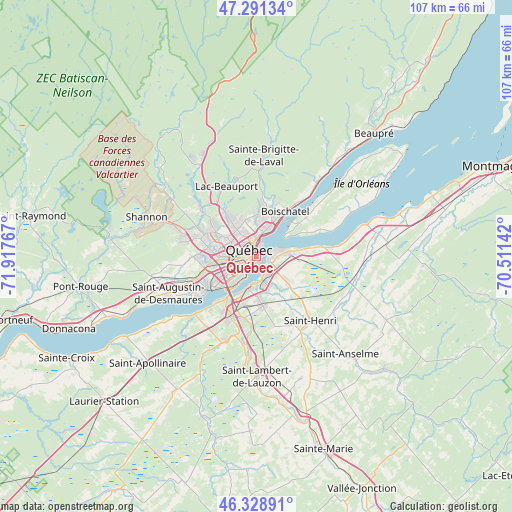
Québec GPS coordinates[2]
46° 48' 44.208" North, 71° 12' 52.344" West
| Map corner | latitude | longitude |
|---|---|---|
| Upper-left | 47.29134°, | -71.91767° |
| Center: | 46.81228°, | -71.21454° |
| Lower-right: | 46.32891°, | -70.51142° |
| Map W x H: | 107×107 km | = 66.5×66.5mi |
| max Lat: | 73.03752° ⇑52.6% North |
| Québec: | 46.81228° |
| min Lat: | ⇓47.4% South 42.05009° |
| min Long | Québec | max Long |
| -139.43328° | -71.21454° | -52.70931° |
| W 80.3%⇐ | ⇒19.7% E |
Elevation
Elevation of Québec is 54 m = 177 ft, and this is 200.4 m = 657 ft below average elevation for this country.
| Max E: |
1518 m = 4980 ft | 70.3% |
| Avg. | 254.4 m = 835 ft | |
| Québec | 54 m = 177 ft | |
Min E: |
-2 m = -7 ft | 29.7% |
See also: Québec elevation on elevation.city.
Geographical zone
Québec is located in North temperate zone (between Tropic of Cancer and the Arctic Circle). Distance of this North polar circle is 2196.1 km =1364.6 mi to North.| Distance of | km | miles | from Québec |
|---|---|---|---|
| North Pole | 4802 | 2983.8 | to North |
| Arctic Circle | 2196.1 | 1364.6 | to North |
| Tropic Cancer | 2599.1 | 1615 | to South |
| Equator | 5205 | 3234.2 | to South |


Nearby cities:
15 places around Québec: (largest is in red/bold)
• Breakeyville
14.7 km =9.1 mi,  182°
182°
• Château-Richer
21.5 km =13.4 mi,  40°
40°
• Fossambault-sur-le-Lac
31.3 km =19.4 mi,  283°
283°
• L'Ancienne-Lorette
10.7 km =6.6 mi,  258°
258°
• L'Ange-Gardien
15.6 km =9.7 mi, 40°
• La Haute-Saint-Charles
14.8 km =9.2 mi,  305°
305°
• Lévis
3 km =1.9 mi,  109°
109°
• Neuville
30.8 km =19.1 mi,  245°
245°
• Saint-Anselme
27.4 km =17 mi,  137°
137°
• Saint-Antoine-de-Tilly
32 km =19.9 mi,  238°
238°
• Saint-Augustin-de-Desmaures
19.7 km =12.2 mi, 246°
• Saint-Henri
17.3 km =10.7 mi, 140°
• Saint-Lambert-de-Lauzon
25.1 km =15.6 mi, 179°
• Sainte Catherine de la Jacques Cartier
31.2 km =19.4 mi, 278°
• Shannon
24 km =14.9 mi,  288°
288°
Sources, notices
• [Note1] Compared only with cities in Canada existing in our database
• [Src1] Map data: © OpenStreetMap contributors (CC-BY-SA)
• [Src2] Other city data from geonames.org with taken over terms of usage.
• [Src3] Geographical zone / Annual Mean Temperature by Robert A. Rohde @ Wikipedia
