Lévis geodata
Lévis (Quebec) is a populated place; located in Canada in America/Blanc-Sablon (GMT-4) time zone. With population of 126,396 people, there are 43 cities with bigger population in this country. Compared to other cities in Canada, 52.7% of cities are located further ↑North; 80.5% of cities are located further ←West and 62.9% of cities have higher elevation than Lévis. Note1


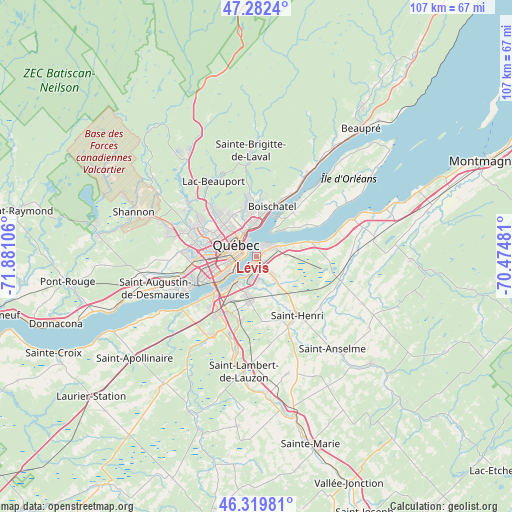
Lévis GPS coordinates[2]
46° 48' 11.736" North, 71° 10' 40.548" West
| Map corner | latitude | longitude |
|---|---|---|
| Upper-left | 47.2824°, | -71.88106° |
| Center: | 46.80326°, | -71.17793° |
| Lower-right: | 46.31981°, | -70.47481° |
| Map W x H: | 107×107 km | = 66.5×66.5mi |
| max Lat: | 73.03752° ⇑52.7% North |
| Lévis: | 46.80326° |
| min Lat: | ⇓47.3% South 42.05009° |
| min Long | Lévis | max Long |
| -139.43328° | -71.17793° | -52.70931° |
| W 80.5%⇐ | ⇒19.5% E |
Elevation
Elevation of Lévis is 87 m = 285 ft, and this is 167.4 m = 549 ft below average elevation for this country.
| Max E: |
1518 m = 4980 ft | 62.9% |
| Avg. | 254.4 m = 835 ft | |
| Lévis | 87 m = 285 ft | |
Min E: |
-2 m = -7 ft | 37.1% |
See also: Lévis elevation on elevation.city.
Geographical zone
Lévis is located in North temperate zone (between Tropic of Cancer and the Arctic Circle). Distance of this North polar circle is 2197.1 km =1365.2 mi to North.| Distance of | km | miles | from Lévis |
|---|---|---|---|
| North Pole | 4803 | 2984.4 | to North |
| Arctic Circle | 2197.1 | 1365.2 | to North |
| Tropic Cancer | 2598.1 | 1614.4 | to South |
| Equator | 5204 | 3233.6 | to South |


Nearby cities:
15 places around Lévis: (largest is in red/bold)
• Beaupré
34.3 km =21.3 mi,  38°
38°
• Breakeyville
14.1 km =8.8 mi,  194°
194°
• Château-Richer
20.7 km =12.9 mi,  32°
32°
• L'Ancienne-Lorette
13.3 km =8.3 mi,  265°
265°
• L'Ange-Gardien
14.8 km =9.2 mi, 29°
• La Haute-Saint-Charles
17.7 km =11 mi,  303°
303°
• Neuville
33 km =20.5 mi,  249°
249°
• Québec
3 km =1.9 mi,  289°
289°
• Saint-Anselme
24.9 km =15.5 mi,  141°
141°
• Saint-Antoine-de-Tilly
33.9 km =21.1 mi,  242°
242°
• Saint-Augustin-de-Desmaures
22 km =13.7 mi, 251°
• Saint-Henri
14.8 km =9.2 mi,  145°
145°
• Saint-Lambert-de-Lauzon
24.2 km =15 mi, 185°
• Sainte Catherine de la Jacques Cartier
34.1 km =21.2 mi,  279°
279°
• Shannon
27 km =16.8 mi, 288°
Sources, notices
• [Note1] Compared only with cities in Canada existing in our database
• [Src1] Map data: © OpenStreetMap contributors (CC-BY-SA)
• [Src2] Other city data from geonames.org with taken over terms of usage.
• [Src3] Geographical zone / Annual Mean Temperature by Robert A. Rohde @ Wikipedia
