Forestville geodata
Forestville (Quebec) is a populated place; located in Canada in America/Toronto (GMT-4) time zone. With population of 2,333 people, there are 698 cities with bigger population in this country. Compared to other cities in Canada, 59.7% of cities are located further ↓South; 83.8% of cities are located further ←West and 63.6% of cities have higher elevation than Forestville. Note1


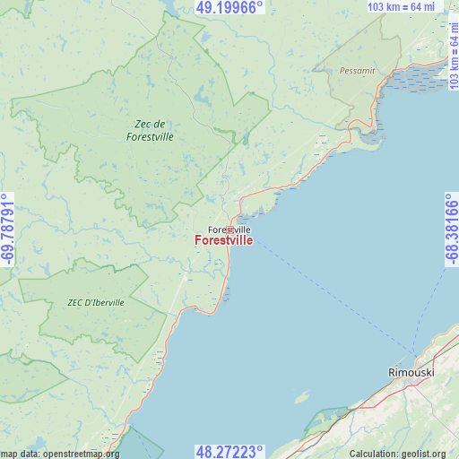
Forestville GPS coordinates[2]
48° 44' 17.088" North, 69° 5' 5.208" West
| Map corner | latitude | longitude |
|---|---|---|
| Upper-left | 49.19966°, | -69.78791° |
| Center: | 48.73808°, | -69.08478° |
| Lower-right: | 48.27223°, | -68.38166° |
| Map W x H: | 103.1×103.1 km | = 64.1×64.1mi |
| max Lat: | 73.03752° ⇑40.3% North |
| Forestville: | 48.73808° |
| min Lat: | ⇓59.7% South 42.05009° |
| min Long | Forestville | max Long |
| -139.43328° | -69.08478° | -52.70931° |
| W 83.8%⇐ | ⇒16.2% E |
Elevation
Elevation of Forestville is 84 m = 276 ft, and this is 170.4 m = 559 ft below average elevation for this country.
| Max E: |
1518 m = 4980 ft | 63.6% |
| Avg. | 254.4 m = 835 ft | |
| Forestville | 84 m = 276 ft | |
Min E: |
-2 m = -7 ft | 36.4% |
See also: Canada elevation on elevation.city.
Geographical zone
Forestville is located in North temperate zone (between Tropic of Cancer and the Arctic Circle). Distance of this North polar circle is 1982 km =1231.6 mi to North.| Distance of | km | miles | from Forestville |
|---|---|---|---|
| North Pole | 4587.9 | 2850.8 | to North |
| Arctic Circle | 1982 | 1231.6 | to North |
| Tropic Cancer | 2813.2 | 1748 | to South |
| Equator | 5419.2 | 3367.3 | to South |


Nearby cities:
15 places around Forestville: (largest is in red/bold)
• Baie-Comeau
86.6 km =53.8 mi,  52°
52°
• Cacouna
96.4 km =59.9 mi,  198°
198°
• Chute-aux-Outardes
65.4 km =40.6 mi, 49°
• Hauterive
78.9 km =49 mi, 49°
• Labrieville
71.6 km =44.5 mi,  330°
330°
• Lac-des-Aigles
88.4 km =54.9 mi,  160°
160°
• Le Bic
49.5 km =30.8 mi,  144°
144°
• Les Escoumins
49.1 km =30.5 mi,  208°
208°
• Luceville
54.9 km =34.1 mi,  113°
113°
• Mont-Joli
67.8 km =42.1 mi,  104°
104°
• Rimouski
52.3 km =32.5 mi,  127°
127°
• Rivière-du-Loup
106.8 km =66.4 mi, 198°
• Sacré-Coeur
77.3 km =48 mi,  223°
223°
• Saint-Mathieu-de-Rioux
62.1 km =38.6 mi,  173°
173°
• Tadoussac
80.3 km =49.9 mi, 215°
Sources, notices
• [Note1] Compared only with cities in Canada existing in our database
• [Src1] Map data: © OpenStreetMap contributors (CC-BY-SA)
• [Src2] Other city data from geonames.org with taken over terms of usage.
• [Src3] Geographical zone / Annual Mean Temperature by Robert A. Rohde @ Wikipedia
