Sacré-Coeur geodata
Sacré-Coeur (Quebec) is a populated place; located in Canada in America/Toronto (GMT-4) time zone. With population of 1,881 people, there are 774 cities with bigger population in this country. Compared to other cities in Canada, 55.6% of cities are located further ↓South; 83.1% of cities are located further ←West and 57.7% of cities have higher elevation than Sacré-Coeur. Note1


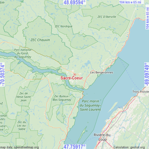
Sacré-Coeur GPS coordinates[2]
48° 13' 46.92" North, 69° 48' 2.196" West
| Map corner | latitude | longitude |
|---|---|---|
| Upper-left | 48.69594°, | -70.50374° |
| Center: | 48.2297°, | -69.80061° |
| Lower-right: | 47.75917°, | -69.09749° |
| Map W x H: | 104.2×104.2 km | = 64.7×64.7mi |
| max Lat: | 73.03752° ⇑44.4% North |
| Sacré-Coeur: | 48.2297° |
| min Lat: | ⇓55.6% South 42.05009° |
| min Long | Sacré-Coeur | max Long |
| -139.43328° | -69.80061° | -52.70931° |
| W 83.1%⇐ | ⇒16.9% E |
Elevation
Elevation of Sacré-Coeur is 115 m = 377 ft, and this is 139.4 m = 457 ft below average elevation for this country.
| Max E: |
1518 m = 4980 ft | 57.7% |
| Avg. | 254.4 m = 835 ft | |
| Sacré-Coeur | 115 m = 377 ft | |
Min E: |
-2 m = -7 ft | 42.3% |
See also: Canada elevation on elevation.city.
Geographical zone
Sacré-Coeur is located in North temperate zone (between Tropic of Cancer and the Arctic Circle). Distance of this North polar circle is 2038.5 km =1266.7 mi to North.| Distance of | km | miles | from Sacré-Coeur |
|---|---|---|---|
| North Pole | 4644.4 | 2885.9 | to North |
| Arctic Circle | 2038.5 | 1266.7 | to North |
| Tropic Cancer | 2756.7 | 1712.9 | to South |
| Equator | 5362.6 | 3332.2 | to South |


Nearby cities:
15 places around Sacré-Coeur: (largest is in red/bold)
• Cabano
91.9 km =57.1 mi,  131°
131°
• Cacouna
41.3 km =25.7 mi,  147°
147°
• Forestville
77.3 km =48 mi,  43°
43°
• Kamouraska
74 km =46 mi,  183°
183°
• La Malbaie
69.2 km =43 mi,  202°
202°
• Lac-des-Aigles
87.5 km =54.4 mi,  107°
107°
• Le Bic
83.4 km =51.8 mi,  78°
78°
• Les Escoumins
32.1 km =19.9 mi,  64°
64°
• Rivière-du-Loup
48.7 km =30.3 mi,  156°
156°
• Saint-André
61.6 km =38.3 mi,  174°
174°
• Saint-Antonin
57.4 km =35.7 mi, 155°
• Saint-Mathieu-de-Rioux
60.5 km =37.6 mi,  94°
94°
• Saint-Pascal
79.1 km =49.2 mi, 180°
• Saint-Siméon
43.2 km =26.8 mi,  187°
187°
• Tadoussac
10.8 km =6.7 mi,  144°
144°
Sources, notices
• [Note1] Compared only with cities in Canada existing in our database
• [Src1] Map data: © OpenStreetMap contributors (CC-BY-SA)
• [Src2] Other city data from geonames.org with taken over terms of usage.
• [Src3] Geographical zone / Annual Mean Temperature by Robert A. Rohde @ Wikipedia
