Kamouraska geodata
Kamouraska (Quebec) is a populated place; located in Canada in America/Toronto (GMT-4) time zone. With population of 589 people, there are 1152 cities with bigger population in this country. Compared to other cities in Canada, 51.5% of cities are located further ↓South; 82.9% of cities are located further ←West and 97.8% of cities have higher elevation than Kamouraska. Note1


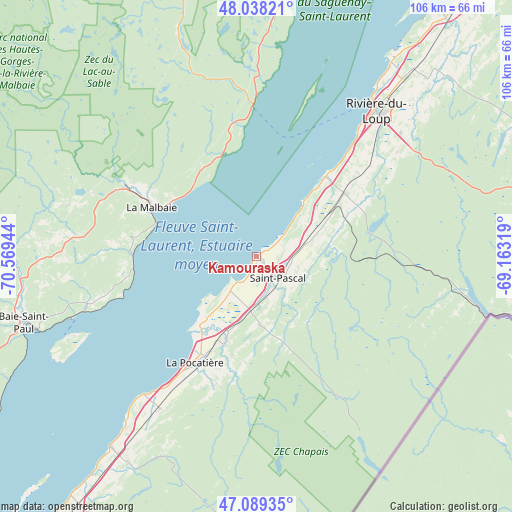
Kamouraska GPS coordinates[2]
47° 33' 57.348" North, 69° 51' 58.716" West
| Map corner | latitude | longitude |
|---|---|---|
| Upper-left | 48.03821°, | -70.56944° |
| Center: | 47.56593°, | -69.86631° |
| Lower-right: | 47.08935°, | -69.16319° |
| Map W x H: | 105.5×105.5 km | = 65.6×65.6mi |
| max Lat: | 73.03752° ⇑48.5% North |
| Kamouraska: | 47.56593° |
| min Lat: | ⇓51.5% South 42.05009° |
| min Long | Kamouraska | max Long |
| -139.43328° | -69.86631° | -52.70931° |
| W 82.9%⇐ | ⇒17.1% E |
Elevation
Elevation of Kamouraska is 4 m = 13 ft, and this is 250.4 m = 822 ft below average elevation for this country.
| Max E: |
1518 m = 4980 ft | 97.8% |
| Avg. | 254.4 m = 835 ft | |
| Kamouraska | 4 m = 13 ft | |
Min E: |
-2 m = -7 ft | 2.2% |
See also: Canada elevation on elevation.city.
Geographical zone
Kamouraska is located in North temperate zone (between Tropic of Cancer and the Arctic Circle). Distance of this North polar circle is 2112.3 km =1312.5 mi to North.| Distance of | km | miles | from Kamouraska |
|---|---|---|---|
| North Pole | 4718.2 | 2931.8 | to North |
| Arctic Circle | 2112.3 | 1312.5 | to North |
| Tropic Cancer | 2682.9 | 1667.1 | to South |
| Equator | 5288.8 | 3286.3 | to South |


Nearby cities:
15 places around Kamouraska: (largest is in red/bold)
• Baie-Saint-Paul
49.5 km =30.8 mi,  253°
253°
• Cabano
75.1 km =46.7 mi,  80°
80°
• Cacouna
47.6 km =29.6 mi,  35°
35°
• La Malbaie
23.6 km =14.7 mi,  294°
294°
• La Pocatière
25.5 km =15.8 mi,  209°
209°
• Pohénégamook
49.4 km =30.7 mi,  103°
103°
• Rivière-du-Loup
37.8 km =23.5 mi, 39°
• Sacré-Coeur
74 km =46 mi,  3°
3°
• Saint-André
16.5 km =10.3 mi, 40°
• Saint-Antonin
36.3 km =22.6 mi,  53°
53°
• Saint-Pacôme
19 km =11.8 mi,  199°
199°
• Saint-Pascal
7.1 km =4.4 mi,  138°
138°
• Saint-Siméon
31 km =19.3 mi,  358°
358°
• St-Jean-Port-Joli
49.5 km =30.8 mi,  217°
217°
• Tadoussac
65.9 km =40.9 mi,  9°
9°
Sources, notices
• [Note1] Compared only with cities in Canada existing in our database
• [Src1] Map data: © OpenStreetMap contributors (CC-BY-SA)
• [Src2] Other city data from geonames.org with taken over terms of usage.
• [Src3] Geographical zone / Annual Mean Temperature by Robert A. Rohde @ Wikipedia
