La Pocatière geodata
La Pocatière (Quebec) is a populated place; located in Canada in America/Toronto (GMT-4) time zone. With population of 4,575 people, there are 498 cities with bigger population in this country. Compared to other cities in Canada, 50.4% of cities are located further ↑North; 82.7% of cities are located further ←West and 78.3% of cities have higher elevation than La Pocatière. Note1


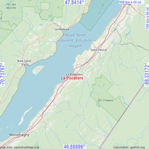
La Pocatière GPS coordinates[2]
47° 22' 2.388" North, 70° 2' 5.424" West
| Map corner | latitude | longitude |
|---|---|---|
| Upper-left | 47.8414°, | -70.73797° |
| Center: | 47.36733°, | -70.03484° |
| Lower-right: | 46.88896°, | -69.33172° |
| Map W x H: | 105.9×105.9 km | = 65.8×65.8mi |
| max Lat: | 73.03752° ⇑50.4% North |
| La Pocatière: | 47.36733° |
| min Lat: | ⇓49.6% South 42.05009° |
| min Long | La Pocatière | max Long |
| -139.43328° | -70.03484° | -52.70931° |
| W 82.7%⇐ | ⇒17.3% E |
Elevation
Elevation of La Pocatière is 35 m = 115 ft, and this is 219.4 m = 720 ft below average elevation for this country.
| Max E: |
1518 m = 4980 ft | 78.3% |
| Avg. | 254.4 m = 835 ft | |
| La Pocatière | 35 m = 115 ft | |
Min E: |
-2 m = -7 ft | 21.7% |
See also: Canada elevation on elevation.city.
Geographical zone
La Pocatière is located in North temperate zone (between Tropic of Cancer and the Arctic Circle). Distance of this North polar circle is 2134.4 km =1326.3 mi to North.| Distance of | km | miles | from La Pocatière |
|---|---|---|---|
| North Pole | 4740.3 | 2945.5 | to North |
| Arctic Circle | 2134.4 | 1326.3 | to North |
| Tropic Cancer | 2660.8 | 1653.3 | to South |
| Equator | 5266.8 | 3272.6 | to South |


Nearby cities:
15 places around La Pocatière: (largest is in red/bold)
• Baie-Saint-Paul
35.8 km =22.2 mi,  283°
283°
• Beaupré
74.3 km =46.2 mi,  241°
241°
• Cacouna
73 km =45.4 mi,  33°
33°
• Kamouraska
25.5 km =15.8 mi, 29°
• La Malbaie
33.1 km =20.6 mi,  344°
344°
• Montmagny
58.3 km =36.2 mi,  222°
222°
• Pohénégamook
61.7 km =38.3 mi,  80°
80°
• Rivière-du-Loup
63 km =39.1 mi,  35°
35°
• Saint-André
41.8 km =26 mi, 34°
• Saint-Antonin
60.5 km =37.6 mi, 43°
• Saint-Bernard-de-l'Île-aux-Coudres
50.7 km =31.5 mi,  229°
229°
• Saint-Pacôme
7.6 km =4.7 mi,  56°
56°
• Saint-Pascal
24.2 km =15 mi,  46°
46°
• Saint-Siméon
54.3 km =33.7 mi,  12°
12°
• St-Jean-Port-Joli
24.6 km =15.3 mi, 226°
Sources, notices
• [Note1] Compared only with cities in Canada existing in our database
• [Src1] Map data: © OpenStreetMap contributors (CC-BY-SA)
• [Src2] Other city data from geonames.org with taken over terms of usage.
• [Src3] Geographical zone / Annual Mean Temperature by Robert A. Rohde @ Wikipedia
