Ladysmith geodata
Ladysmith (British Columbia) is a populated place; located in Canada in America/Vancouver (GMT-7) time zone. With population of 8,740 people, there are 346 cities with bigger population in this country. Compared to other cities in Canada, 61.8% of cities are located further ↓South; 95.9% of cities are located further →East and 66.1% of cities have higher elevation than Ladysmith. Note1
Administrative division(s):
- Level 1: British Columbia
- Level 2: Cowichan Valley Regional District
- Level 3: Ladysmith


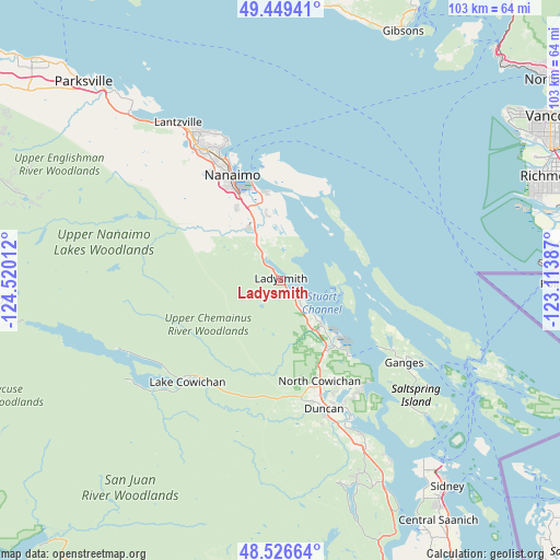
Ladysmith GPS coordinates[2]
48° 59' 24.576" North, 123° 49' 1.164" West
| Map corner | latitude | longitude |
|---|---|---|
| Upper-left | 49.44941°, | -124.52012° |
| Center: | 48.99016°, | -123.81699° |
| Lower-right: | 48.52664°, | -123.11387° |
| Map W x H: | 102.6×102.6 km | = 63.8×63.8mi |
| max Lat: | 73.03752° ⇑38.2% North |
| Ladysmith: | 48.99016° |
| min Lat: | ⇓61.8% South 42.05009° |
| min Long | Ladysmith | max Long |
| -139.43328° | -123.81699° | -52.70931° |
| W 4.1%⇐ | ⇒95.9% E |
Elevation
Elevation of Ladysmith is 71 m = 233 ft, and this is 183.4 m = 602 ft below average elevation for this country.
| Max E: |
1518 m = 4980 ft | 66.1% |
| Avg. | 254.4 m = 835 ft | |
| Ladysmith | 71 m = 233 ft | |
Min E: |
-2 m = -7 ft | 33.9% |
See also: Canada elevation on elevation.city.
Geographical zone
Ladysmith is located in North temperate zone (between Tropic of Cancer and the Arctic Circle). Distance of this North polar circle is 1954 km =1214.2 mi to North.| Distance of | km | miles | from Ladysmith |
|---|---|---|---|
| North Pole | 4559.9 | 2833.4 | to North |
| Arctic Circle | 1954 | 1214.2 | to North |
| Tropic Cancer | 2841.3 | 1765.5 | to South |
| Equator | 5447.2 | 3384.7 | to South |


Nearby cities:
15 places around Ladysmith: (largest is in red/bold)
• Cassidy
8.3 km =5.2 mi,  322°
322°
• Cedar
14.3 km =8.9 mi,  349°
349°
• Chemainus
10.9 km =6.8 mi,  139°
139°
• Cherry Point
36.2 km =22.5 mi,  148°
148°
• Cowichan Bay
32 km =19.9 mi, 152°
• Duncan
24.5 km =15.2 mi,  160°
160°
• East Wellington
25.1 km =15.6 mi, 324°
• Fairwinds
39 km =24.2 mi, 324°
• Lake Cowichan
25.3 km =15.7 mi,  223°
223°
• Nanaimo
21.5 km =13.4 mi,  335°
335°
• North Cowichan
19.1 km =11.9 mi, 149°
• North Oyster/Yellow Point
6.6 km =4.1 mi, 349°
• Salt Spring Island
30.5 km =19 mi,  128°
128°
• Saltair
5.7 km =3.5 mi, 142°
• Youbou
31.4 km =19.5 mi,  243°
243°
Sources, notices
• [Note1] Compared only with cities in Canada existing in our database
• [Src1] Map data: © OpenStreetMap contributors (CC-BY-SA)
• [Src2] Other city data from geonames.org with taken over terms of usage.
• [Src3] Geographical zone / Annual Mean Temperature by Robert A. Rohde @ Wikipedia
