Zürich geodata
Zürich (Zurich) is a seat of a first-order administrative division; located in Switzerland in Europe/Zurich (GMT+2) time zone. With population of 341,730 people, there are 0 cities with bigger population in this country. Compared to other cities in Switzerland, 67.1% of cities are located further ↓South; 61.8% of cities are located further ←West and 76.3% of cities have higher elevation than Zürich. Note1


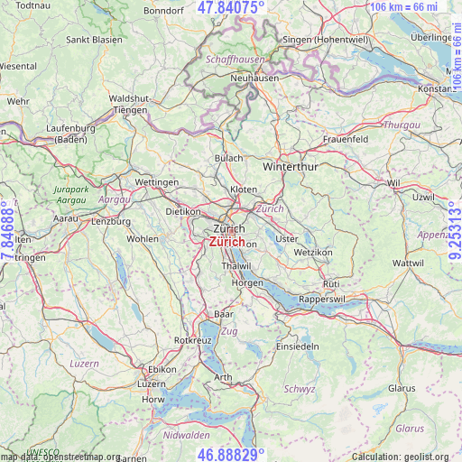
Zürich GPS coordinates[2]
47° 22' 0.012" North, 8° 33' 0" East
| Map corner | latitude | longitude |
|---|---|---|
| Upper-left | 47.84075°, | 7.84688° |
| Center: | 47.36667°, | 8.55° |
| Lower-right: | 46.88829°, | 9.25313° |
| Map W x H: | 105.9×105.9 km | = 65.8×65.8mi |
| max Lat: | 47.76737° ⇑32.9% North |
| Zürich: | 47.36667° |
| min Lat: | ⇓67.1% South 45.83203° |
| min Long | Zürich | max Long |
| 5.97153° | 8.55° | 10.44624° |
| W 61.8%⇐ | ⇒38.2% E |
Elevation
Elevation of Zürich is 429 m = 1407 ft, and this is 129.2 m = 424 ft below average elevation for this country.
| Max E: |
1845 m = 6053 ft | 76.3% |
| Avg. | 558.2 m = 1831 ft | |
| Zürich | 429 m = 1407 ft | |
Min E: |
197 m = 646 ft | 23.7% |
See also: Zürich elevation on elevation.city.
Geographical zone
Zürich is located in North temperate zone (between Tropic of Cancer and the Arctic Circle). Distance of this North polar circle is 2134.5 km =1326.3 mi to North.| Distance of | km | miles | from Zürich |
|---|---|---|---|
| North Pole | 4740.4 | 2945.5 | to North |
| Arctic Circle | 2134.5 | 1326.3 | to North |
| Tropic Cancer | 2660.8 | 1653.3 | to South |
| Equator | 5266.7 | 3272.6 | to South |


Nearby cities:
15 places around Zürich: (largest is in red/bold)
• Zürich (Kreis 1)
0.8 km =0.5 mi,  304°
304°
• Zürich (Kreis 1) / City
1.3 km =0.8 mi, 301°
• Zürich (Kreis 1) / Hochschulen
0.3 km =0.2 mi,  256°
256°
• Zürich (Kreis 1) / Lindenhof
0.9 km =0.6 mi,  308°
308°
• Zürich (Kreis 1) / Rathaus
0.7 km =0.4 mi,  325°
325°
• Zürich (Kreis 2) / Enge
1.6 km =1 mi,  244°
244°
• Zürich (Kreis 4) / Langstrasse
2 km =1.2 mi, 307°
• Zürich (Kreis 4) / Werd
1.9 km =1.2 mi,  287°
287°
• Zürich (Kreis 7) / Fluntern
1.7 km =1.1 mi,  29°
29°
• Zürich (Kreis 7) / Hirslanden
1.4 km =0.9 mi,  109°
109°
• Zürich (Kreis 7) / Hottingen
1.1 km =0.7 mi,  68°
68°
• Zürich (Kreis 8)
1.6 km =1 mi,  147°
147°
• Zürich (Kreis 8) / Mühlebach
1.2 km =0.7 mi, 151°
• Zürich (Kreis 8) / Seefeld
1.4 km =0.9 mi,  163°
163°
• Zürich (Kreis 8) / Weinegg
2.2 km =1.4 mi,  136°
136°
In other languages:
- In Spanish: Zúrich
- In France: Zurich
- In Italian: Zurigo
- In Russian: Цюрих
- In Chinese: 苏黎世
Sources, notices
• [Note1] Compared only with cities in Switzerland existing in our database
• [Src1] Map data: © OpenStreetMap contributors (CC-BY-SA)
• [Src2] Other city data from geonames.org with taken over terms of usage.
• [Src3] Geographical zone / Annual Mean Temperature by Robert A. Rohde @ Wikipedia
