Zürich (Kreis 8) / Seefeld geodata
Zürich (Kreis 8) / Seefeld (Zurich) is a section of populated place; located in Switzerland in Europe/Zurich (GMT+2) time zone. With population of 4,998 people, there are 345 cities with bigger population in this country. Compared to other cities in Switzerland, 65.1% of cities are located further ↓South; 62.2% of cities are located further ←West and 82.9% of cities have higher elevation than Zürich (Kreis 8) / Seefeld. Note1
Current local time in Zürich (Kreis 8) / Seefeld:
07:43 AM, SaturdayDifference from your time zone: hours


Zürich (Kreis 8) / Seefeld GPS coordinates[2]
47° 21' 16.632" North, 8° 33' 19.332" East
| Map corner | latitude | longitude |
|---|---|---|
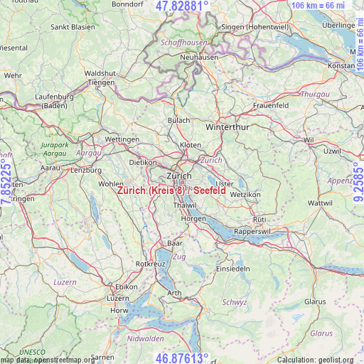
| Upper-left | 47.82881°, | 7.85225° |
| Center: | 47.35462°, | 8.55537° |
| Lower-right: | 46.87613°, | 9.2585° |
| Map W x H: | 105.9×105.9 km | = 65.8×65.8mi |
| max Lat: | 47.76737° ⇑34.9% North |
| Zürich (Kreis 8) / Seefeld: | 47.35462° |
| min Lat: | ⇓65.1% South 45.83203° |
| min Long | Zürich (Kreis | max Long |
| 5.97153° | 8.55537° | 10.44624° |
| W 62.2%⇐ | ⇒37.8% E |
Elevation
Elevation of Zürich (Kreis 8) / Seefeld is 415 m = 1362 ft, and this is 143.2 m = 470 ft below average elevation for this country.
| Max E: |
1845 m = 6053 ft | 82.9% |
| Avg. | 558.2 m = 1831 ft | |
| Zürich (Kreis 8) / Seefeld | 415 m = 1362 ft | |
Min E: |
197 m = 646 ft | 17.1% |
See also: Switzerland elevation on elevation.city.
Geographical zone
Zürich (Kreis 8) / Seefeld is located in North temperate zone (between Tropic of Cancer and the Arctic Circle). Distance of this North polar circle is 2135.8 km =1327.1 mi to North.| Distance of | km | miles | from Zürich (Kreis 8) / Seefeld |
|---|---|---|---|
| North Pole | 4741.7 | 2946.4 | to North |
| Arctic Circle | 2135.8 | 1327.1 | to North |
| Tropic Cancer | 2659.4 | 1652.5 | to South |
| Equator | 5265.3 | 3271.7 | to South |


Nearby cities:
15 places around Zürich (Kreis 8) / Seefeld: (largest is in red/bold)
• Rebwies
2.5 km =1.6 mi,  109°
109°
• Zollikon
2.1 km =1.3 mi,  138°
138°
• Zürich
1.4 km =0.9 mi,  343°
343°
• Zürich (Kreis 1)
2 km =1.2 mi,  329°
329°
• Zürich (Kreis 1) / City
2.5 km =1.6 mi,  323°
323°
• Zürich (Kreis 1) / Hochschulen
1.5 km =0.9 mi, 330°
• Zürich (Kreis 1) / Lindenhof
2.2 km =1.4 mi, 329°
• Zürich (Kreis 1) / Rathaus
2 km =1.2 mi, 337°
• Zürich (Kreis 2) / Enge
1.9 km =1.2 mi,  289°
289°
• Zürich (Kreis 2) / Wollishofen
2.4 km =1.5 mi,  228°
228°
• Zürich (Kreis 7) / Hirslanden
1.3 km =0.8 mi,  46°
46°
• Zürich (Kreis 7) / Hottingen
1.8 km =1.1 mi,  18°
18°
• Zürich (Kreis 8)
0.4 km =0.2 mi,  87°
87°
• Zürich (Kreis 8) / Mühlebach
0.3 km =0.2 mi,  27°
27°
• Zürich (Kreis 8) / Weinegg
1.1 km =0.7 mi,  101°
101°
Sources, notices
• [Note1] Compared only with cities in Switzerland existing in our database
• [Src1] Map data: © OpenStreetMap contributors (CC-BY-SA)
• [Src2] Other city data from geonames.org with taken over terms of usage.
• [Src3] Geographical zone / Annual Mean Temperature by Robert A. Rohde @ Wikipedia
