Weiningen geodata
Weiningen (Zurich) is a populated place; located in Switzerland in Europe/Zurich (GMT+2) time zone. With population of 1,753 people, there are 922 cities with bigger population in this country. Compared to other cities in Switzerland, 77.7% of cities are located further ↓South; 52.2% of cities are located further ←West and 81.2% of cities have higher elevation than Weiningen. Note1


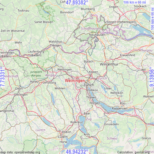
Weiningen GPS coordinates[2]
47° 25' 12.792" North, 8° 26' 11.184" East
| Map corner | latitude | longitude |
|---|---|---|
| Upper-left | 47.89382°, | 7.73331° |
| Center: | 47.42022°, | 8.43644° |
| Lower-right: | 46.94232°, | 9.13956° |
| Map W x H: | 105.8×105.8 km | = 65.7×65.7mi |
| max Lat: | 47.76737° ⇑22.3% North |
| Weiningen: | 47.42022° |
| min Lat: | ⇓77.7% South 45.83203° |
| min Long | Weiningen | max Long |
| 5.97153° | 8.43644° | 10.44624° |
| W 52.2%⇐ | ⇒47.8% E |
Elevation
Elevation of Weiningen is 419 m = 1375 ft, and this is 139.2 m = 457 ft below average elevation for this country.
| Max E: |
1845 m = 6053 ft | 81.2% |
| Avg. | 558.2 m = 1831 ft | |
| Weiningen | 419 m = 1375 ft | |
Min E: |
197 m = 646 ft | 18.8% |
See also: Switzerland elevation on elevation.city.
Geographical zone
Weiningen is located in North temperate zone (between Tropic of Cancer and the Arctic Circle). Distance of this North polar circle is 2128.5 km =1322.6 mi to North.| Distance of | km | miles | from Weiningen |
|---|---|---|---|
| North Pole | 4734.4 | 2941.8 | to North |
| Arctic Circle | 2128.5 | 1322.6 | to North |
| Tropic Cancer | 2666.7 | 1657 | to South |
| Equator | 5272.6 | 3276.2 | to South |


Nearby cities:
15 places around Weiningen: (largest is in red/bold)
• Dällikon / Dällikon (Dorf)
2.2 km =1.4 mi,  3°
3°
• Dällikon / Sytenacher
2.1 km =1.3 mi,  16°
16°
• Fahrweid (nördl. Teil)
1.8 km =1.1 mi,  248°
248°
• Fahrweid (nördl. Teil) / Fahrweid
1.8 km =1.1 mi,  238°
238°
• Fahrweid (südl. Teil)
2.2 km =1.4 mi,  231°
231°
• Geroldswil
1.9 km =1.2 mi,  276°
276°
• Geroldswil / Bergacker
2.2 km =1.4 mi,  286°
286°
• Geroldswil / Haslern
1.5 km =0.9 mi,  271°
271°
• Geroldswil / Huebwiesen
2 km =1.2 mi, 277°
• Oberengstringen / Rauchacher
1.9 km =1.2 mi,  129°
129°
• Oberengstringen / Sonnenberg
2 km =1.2 mi,  116°
116°
• Regensdorf / Hubacher
2.1 km =1.3 mi,  61°
61°
• Regensdorf / Obstgarten
2.4 km =1.5 mi,  69°
69°
• Schlieren / Engstingerquartier
1.9 km =1.2 mi,  164°
164°
• Unterengstringen
1.1 km =0.7 mi, 129°
Sources, notices
• [Note1] Compared only with cities in Switzerland existing in our database
• [Src1] Map data: © OpenStreetMap contributors (CC-BY-SA)
• [Src2] Other city data from geonames.org with taken over terms of usage.
• [Src3] Geographical zone / Annual Mean Temperature by Robert A. Rohde @ Wikipedia
