Villars-sur-Glâne geodata
Villars-sur-Glâne (Fribourg) is a populated place; located in Switzerland in Europe/Zurich (GMT+2) time zone. With population of 10,021 people, there are 149 cities with bigger population in this country. Compared to other cities in Switzerland, 74.9% of cities are located further ↑North; 84.3% of cities are located further →East and 79.6% of cities have lower elevation than Villars-sur-Glâne. Note1


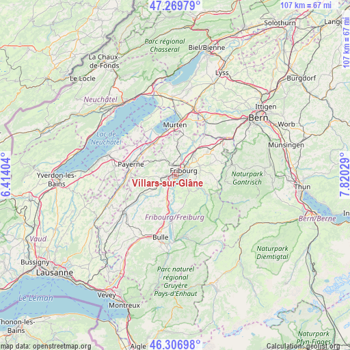
Villars-sur-Glâne GPS coordinates[2]
46° 47' 25.944" North, 7° 7' 1.812" East
| Map corner | latitude | longitude |
|---|---|---|
| Upper-left | 47.26979°, | 6.41404° |
| Center: | 46.79054°, | 7.11717° |
| Lower-right: | 46.30698°, | 7.82029° |
| Map W x H: | 107.1×107.1 km | = 66.5×66.5mi |
| max Lat: | 47.76737° ⇑74.9% North |
| Villars-sur-Glâne: | 46.79054° |
| min Lat: | ⇓25.1% South 45.83203° |
| min Long | Villars-sur-Gl� | max Long |
| 5.97153° | 7.11717° | 10.44624° |
| W 15.7%⇐ | ⇒84.3% E |
Elevation
Elevation of Villars-sur-Glâne is 656 m = 2152 ft, and this is 97.8 m = 321 ft above average elevation for this country.
| Max E: |
1845 m = 6053 ft | 20.4% |
| Villars-sur-Glâne | 656 m 2152 ft | |
| Avg. | 558.2 m = 1831 ft | |
Min E: |
197 m = 646 ft | 79.6% |
See also: Switzerland elevation on elevation.city.
Geographical zone
Villars-sur-Glâne is located in North temperate zone (between Tropic of Cancer and the Arctic Circle). Distance of this North polar circle is 2198.6 km =1366.1 mi to North.| Distance of | km | miles | from Villars-sur-Glâne |
|---|---|---|---|
| North Pole | 4804.4 | 2985.3 | to North |
| Arctic Circle | 2198.6 | 1366.1 | to North |
| Tropic Cancer | 2596.7 | 1613.5 | to South |
| Equator | 5202.6 | 3232.7 | to South |


Nearby cities:
15 places around Villars-sur-Glâne: (largest is in red/bold)
• Arconciel
4.8 km =3 mi,  176°
176°
• Avry-sur-Matran
3.8 km =2.4 mi,  264°
264°
• Belfaux
3.6 km =2.2 mi,  347°
347°
• Corminboeuf
2.4 km =1.5 mi,  337°
337°
• Ecuvillens
4.5 km =2.8 mi,  215°
215°
• Ependes
4.7 km =2.9 mi,  151°
151°
• Fribourg
2.9 km =1.8 mi,  63°
63°
• Givisiez
2.5 km =1.6 mi,  16°
16°
• Grolley
5.9 km =3.7 mi,  323°
323°
• Marly
4 km =2.5 mi,  113°
113°
• Matran
1.6 km =1 mi,  250°
250°
• Noréaz
6.9 km =4.3 mi,  280°
280°
• Ponthaux
6.4 km =4 mi,  295°
295°
• Praroman
6.3 km =3.9 mi,  133°
133°
• Treyvaux
7.1 km =4.4 mi,  167°
167°
Sources, notices
• [Note1] Compared only with cities in Switzerland existing in our database
• [Src1] Map data: © OpenStreetMap contributors (CC-BY-SA)
• [Src2] Other city data from geonames.org with taken over terms of usage.
• [Src3] Geographical zone / Annual Mean Temperature by Robert A. Rohde @ Wikipedia
