Treyvaux geodata
Treyvaux (Fribourg) is a populated place; located in Switzerland in Europe/Zurich (GMT+2) time zone. With population of 1,349 people, there are 1107 cities with bigger population in this country. Compared to other cities in Switzerland, 77.4% of cities are located further ↑North; 83.7% of cities are located further →East and 88.1% of cities have lower elevation than Treyvaux. Note1


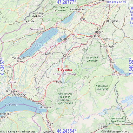
Treyvaux GPS coordinates[2]
46° 43' 40.656" North, 7° 8' 15.684" East
| Map corner | latitude | longitude |
|---|---|---|
| Upper-left | 47.20777°, | 6.43457° |
| Center: | 46.72796°, | 7.13769° |
| Lower-right: | 46.24384°, | 7.84082° |
| Map W x H: | 107.2×107.2 km | = 66.6×66.6mi |
| max Lat: | 47.76737° ⇑77.4% North |
| Treyvaux: | 46.72796° |
| min Lat: | ⇓22.6% South 45.83203° |
| min Long | Treyvaux | max Long |
| 5.97153° | 7.13769° | 10.44624° |
| W 16.3%⇐ | ⇒83.7% E |
Elevation
Elevation of Treyvaux is 783 m = 2569 ft, and this is 224.8 m = 738 ft above average elevation for this country.
| Max E: |
1845 m = 6053 ft | 11.9% |
| Treyvaux | 783 m 2569 ft | |
| Avg. | 558.2 m = 1831 ft | |
Min E: |
197 m = 646 ft | 88.1% |
See also: Switzerland elevation on elevation.city.
Geographical zone
Treyvaux is located in North temperate zone (between Tropic of Cancer and the Arctic Circle). Distance of this North polar circle is 2205.5 km =1370.4 mi to North.| Distance of | km | miles | from Treyvaux |
|---|---|---|---|
| North Pole | 4811.4 | 2989.7 | to North |
| Arctic Circle | 2205.5 | 1370.4 | to North |
| Tropic Cancer | 2589.7 | 1609.2 | to South |
| Equator | 5195.7 | 3228.5 | to South |


Nearby cities:
15 places around Treyvaux: (largest is in red/bold)
• Arconciel
2.5 km =1.6 mi,  330°
330°
• Avry-sur-Matran
8.5 km =5.3 mi,  321°
321°
• Ecuvillens
5.3 km =3.3 mi,  308°
308°
• Ependes
2.9 km =1.8 mi,  12°
12°
• Fribourg
8.3 km =5.2 mi, 7°
• Giffers
6.6 km =4.1 mi,  54°
54°
• Hauteville
6.8 km =4.2 mi,  197°
197°
• La Roche
3.5 km =2.2 mi,  180°
180°
• Marly
5.7 km =3.5 mi,  20°
20°
• Matran
7.1 km =4.4 mi, 334°
• Plasselb
8.7 km =5.4 mi,  84°
84°
• Pont-la-Ville
3.9 km =2.4 mi,  211°
211°
• Praroman
4 km =2.5 mi, 49°
• Rechthalten
9 km =5.6 mi,  60°
60°
• Villars-sur-Glâne
7.1 km =4.4 mi,  347°
347°
Sources, notices
• [Note1] Compared only with cities in Switzerland existing in our database
• [Src1] Map data: © OpenStreetMap contributors (CC-BY-SA)
• [Src2] Other city data from geonames.org with taken over terms of usage.
• [Src3] Geographical zone / Annual Mean Temperature by Robert A. Rohde @ Wikipedia
