Verbier geodata
Verbier (Valais) is a populated place; located in Switzerland in Europe/Zurich (GMT+2) time zone. With population of 2,000 people, there are 832 cities with bigger population in this country. Compared to other cities in Switzerland, 97.5% of cities are located further ↑North; 81.3% of cities are located further →East and 99% of cities have lower elevation than Verbier. Note1


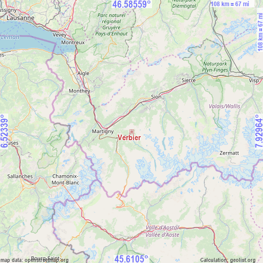
Verbier GPS coordinates[2]
46° 6' 0.72" North, 7° 13' 35.436" East
| Map corner | latitude | longitude |
|---|---|---|
| Upper-left | 46.58559°, | 6.52339° |
| Center: | 46.1002°, | 7.22651° |
| Lower-right: | 45.6105°, | 7.92964° |
| Map W x H: | 108.4×108.4 km | = 67.4×67.4mi |
| max Lat: | 47.76737° ⇑97.5% North |
| Verbier: | 46.1002° |
| min Lat: | ⇓2.5% South 45.83203° |
| min Long | Verbier | max Long |
| 5.97153° | 7.22651° | 10.44624° |
| W 18.7%⇐ | ⇒81.3% E |
Elevation
Elevation of Verbier is 1515 m = 4970 ft, and this is 956.8 m = 3139 ft above average elevation for this country.
| Max E: |
1845 m = 6053 ft | 1% |
| Verbier | 1515 m 4970 ft | |
| Avg. | 558.2 m = 1831 ft | |
Min E: |
197 m = 646 ft | 99% |
See also: Switzerland elevation on elevation.city.
Geographical zone
Verbier is located in North temperate zone (between Tropic of Cancer and the Arctic Circle). Distance of this North polar circle is 2275.3 km =1413.8 mi to North.| Distance of | km | miles | from Verbier |
|---|---|---|---|
| North Pole | 4881.2 | 3033 | to North |
| Arctic Circle | 2275.3 | 1413.8 | to North |
| Tropic Cancer | 2519.9 | 1565.8 | to South |
| Equator | 5125.9 | 3185.1 | to South |


Nearby cities:
15 places around Verbier: (largest is in red/bold)
• Ardon
12.4 km =7.7 mi,  12°
12°
• Bagnes
2 km =1.2 mi,  202°
202°
• Basse-Nendaz
12 km =7.5 mi,  33°
33°
• Chamoson
11.4 km =7.1 mi,  358°
358°
• Charrat
7.8 km =4.8 mi,  290°
290°
• Fully
9.6 km =6 mi,  296°
296°
• Iserables
7 km =4.3 mi, 11°
• Leytron
9.7 km =6 mi,  351°
351°
• Liddes
12.4 km =7.7 mi,  194°
194°
• Martigny-Ville
11.9 km =7.4 mi,  271°
271°
• Orsières
10.1 km =6.3 mi,  218°
218°
• Riddes
8.1 km =5 mi, 358°
• Saillon
8.4 km =5.2 mi,  339°
339°
• Saxon
6.7 km =4.2 mi,  324°
324°
• Sembrancher
6.2 km =3.9 mi,  246°
246°
Sources, notices
• [Note1] Compared only with cities in Switzerland existing in our database
• [Src1] Map data: © OpenStreetMap contributors (CC-BY-SA)
• [Src2] Other city data from geonames.org with taken over terms of usage.
• [Src3] Geographical zone / Annual Mean Temperature by Robert A. Rohde @ Wikipedia
