Martigny-Ville geodata
Martigny-Ville (Valais) is a seat of a second-order administrative division; located in Switzerland in Europe/Zurich (GMT+2) time zone. With population of 14,768 people, there are 86 cities with bigger population in this country. Compared to other cities in Switzerland, 97.5% of cities are located further ↑North; 85.6% of cities are located further →East and 51.4% of cities have higher elevation than Martigny-Ville. Note1


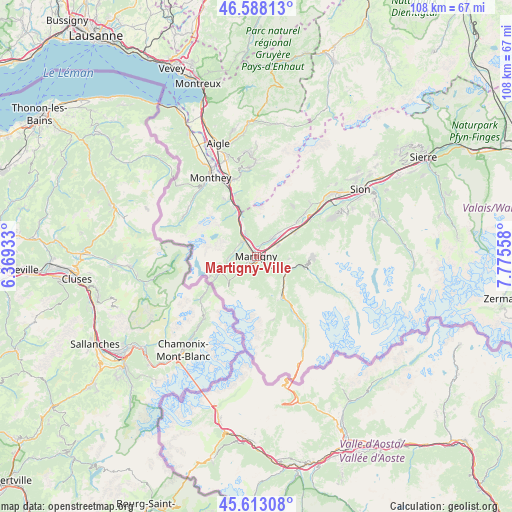
Martigny-Ville GPS coordinates[2]
46° 6' 9.936" North, 7° 4' 20.82" East
| Map corner | latitude | longitude |
|---|---|---|
| Upper-left | 46.58813°, | 6.36933° |
| Center: | 46.10276°, | 7.07245° |
| Lower-right: | 45.61308°, | 7.77558° |
| Map W x H: | 108.4×108.4 km | = 67.4×67.4mi |
| max Lat: | 47.76737° ⇑97.5% North |
| Martigny-Ville: | 46.10276° |
| min Lat: | ⇓2.5% South 45.83203° |
| min Long | Martigny-Ville | max Long |
| 5.97153° | 7.07245° | 10.44624° |
| W 14.4%⇐ | ⇒85.6% E |
Elevation
Elevation of Martigny-Ville is 475 m = 1558 ft, and this is 83.2 m = 273 ft below average elevation for this country.
| Max E: |
1845 m = 6053 ft | 51.4% |
| Avg. | 558.2 m = 1831 ft | |
| Martigny-Ville | 475 m = 1558 ft | |
Min E: |
197 m = 646 ft | 48.6% |
See also: Switzerland elevation on elevation.city.
Geographical zone
Martigny-Ville is located in North temperate zone (between Tropic of Cancer and the Arctic Circle). Distance of this North polar circle is 2275 km =1413.6 mi to North.| Distance of | km | miles | from Martigny-Ville |
|---|---|---|---|
| North Pole | 4880.9 | 3032.8 | to North |
| Arctic Circle | 2275 | 1413.6 | to North |
| Tropic Cancer | 2520.2 | 1566 | to South |
| Equator | 5126.1 | 3185.2 | to South |


Nearby cities:
15 places around Martigny-Ville: (largest is in red/bold)
• Bagnes
11.3 km =7 mi,  100°
100°
• Charrat
5.2 km =3.2 mi,  61°
61°
• Dorénaz
5.6 km =3.5 mi,  336°
336°
• Evionnaz
9.5 km =5.9 mi, 336°
• Fully
5.1 km =3.2 mi,  39°
39°
• Martigny-Combe
3.2 km =2 mi,  211°
211°
• Mex
10.8 km =6.7 mi,  328°
328°
• Orsières
9.9 km =6.2 mi,  145°
145°
• Saillon
11.6 km =7.2 mi,  49°
49°
• Saint-Maurice
13.9 km =8.6 mi, 337°
• Salvan
4.4 km =2.7 mi,  294°
294°
• Saxon
9.5 km =5.9 mi, 56°
• Sembrancher
6.8 km =4.2 mi,  114°
114°
• Verbier
11.9 km =7.4 mi,  91°
91°
• Vernayaz
4.6 km =2.9 mi, 325°
Sources, notices
• [Note1] Compared only with cities in Switzerland existing in our database
• [Src1] Map data: © OpenStreetMap contributors (CC-BY-SA)
• [Src2] Other city data from geonames.org with taken over terms of usage.
• [Src3] Geographical zone / Annual Mean Temperature by Robert A. Rohde @ Wikipedia
