Veltheim geodata
Veltheim (Aargau) is a populated place; located in Switzerland in Europe/Zurich (GMT+2) time zone. With population of 1,374 people, there are 1100 cities with bigger population in this country. Compared to other cities in Switzerland, 80.6% of cities are located further ↓South; 56.8% of cities are located further →East and 93.5% of cities have higher elevation than Veltheim. Note1


Veltheim GPS coordinates[2]
47° 26' 16.656" North, 8° 8' 49.992" East
| Map corner | latitude | longitude |
|---|---|---|
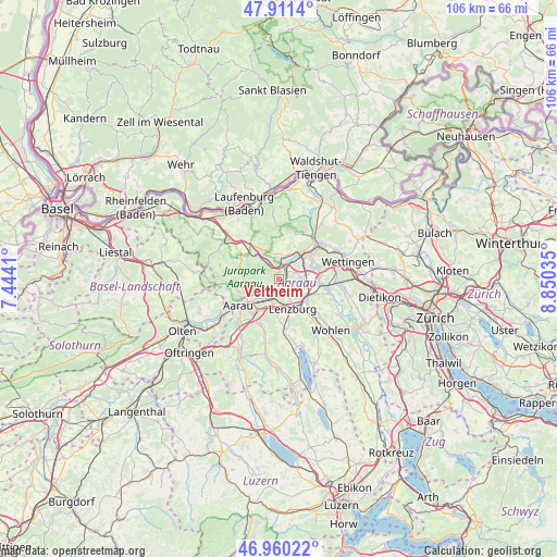
| Upper-left | 47.9114°, | 7.4441° |
| Center: | 47.43796°, | 8.14722° |
| Lower-right: | 46.96022°, | 8.85035° |
| Map W x H: | 105.8×105.8 km | = 65.7×65.7mi |
| max Lat: | 47.76737° ⇑19.4% North |
| Veltheim: | 47.43796° |
| min Lat: | ⇓80.6% South 45.83203° |
| min Long | Veltheim | max Long |
| 5.97153° | 8.14722° | 10.44624° |
| W 43.2%⇐ | ⇒56.8% E |
Elevation
Elevation of Veltheim is 376 m = 1234 ft, and this is 182.2 m = 598 ft below average elevation for this country.
| Max E: |
1845 m = 6053 ft | 93.5% |
| Avg. | 558.2 m = 1831 ft | |
| Veltheim | 376 m = 1234 ft | |
Min E: |
197 m = 646 ft | 6.5% |
See also: Switzerland elevation on elevation.city.
Geographical zone
Veltheim is located in North temperate zone (between Tropic of Cancer and the Arctic Circle). Distance of this North polar circle is 2126.6 km =1321.4 mi to North.| Distance of | km | miles | from Veltheim |
|---|---|---|---|
| North Pole | 4732.5 | 2940.6 | to North |
| Arctic Circle | 2126.6 | 1321.4 | to North |
| Tropic Cancer | 2668.7 | 1658.3 | to South |
| Equator | 5274.6 | 3277.5 | to South |


Nearby cities:
15 places around Veltheim: (largest is in red/bold)
• Biberstein
5.3 km =3.3 mi,  242°
242°
• Birr
4.7 km =2.9 mi,  94°
94°
• Brugg
6.6 km =4.1 mi,  44°
44°
• Effingen
6.6 km =4.1 mi,  329°
329°
• Hausen
5.5 km =3.4 mi,  58°
58°
• Lenzburg
5.9 km =3.7 mi,  159°
159°
• Niederlenz
4.7 km =2.9 mi,  152°
152°
• Othmarsingen
6.5 km =4 mi,  129°
129°
• Rupperswil
4.3 km =2.7 mi,  198°
198°
• Schinznach Bad
2.1 km =1.3 mi,  50°
50°
• Schinznach Dorf
1.1 km =0.7 mi, 333°
• Staufen
6.4 km =4 mi,  166°
166°
• Thalheim
3.5 km =2.2 mi,  265°
265°
• Villnachern
3.8 km =2.4 mi,  14°
14°
• Zeihen
6.3 km =3.9 mi,  312°
312°
Sources, notices
• [Note1] Compared only with cities in Switzerland existing in our database
• [Src1] Map data: © OpenStreetMap contributors (CC-BY-SA)
• [Src2] Other city data from geonames.org with taken over terms of usage.
• [Src3] Geographical zone / Annual Mean Temperature by Robert A. Rohde @ Wikipedia
