Biberstein geodata
Biberstein (Aargau) is a seat of a third-order administrative division; located in Switzerland in Europe/Zurich (GMT+2) time zone. In our database, there are 1823 cities with bigger population. Compared to other cities in Switzerland, 77.1% of cities are located further ↓South; 58.1% of cities are located further →East and 83.8% of cities have higher elevation than Biberstein. Note1


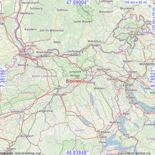
Biberstein GPS coordinates[2]
47° 24' 59.076" North, 8° 5' 6.288" East
| Map corner | latitude | longitude |
|---|---|---|
| Upper-left | 47.89004°, | 7.38196° |
| Center: | 47.41641°, | 8.08508° |
| Lower-right: | 46.93848°, | 8.78821° |
| Map W x H: | 105.8×105.8 km | = 65.7×65.7mi |
| max Lat: | 47.76737° ⇑22.9% North |
| Biberstein: | 47.41641° |
| min Lat: | ⇓77.1% South 45.83203° |
| min Long | Biberstein | max Long |
| 5.97153° | 8.08508° | 10.44624° |
| W 41.9%⇐ | ⇒58.1% E |
Elevation
Elevation of Biberstein is 413 m = 1355 ft, and this is 145.2 m = 476 ft below average elevation for this country.
| Max E: |
1845 m = 6053 ft | 83.8% |
| Avg. | 558.2 m = 1831 ft | |
| Biberstein | 413 m = 1355 ft | |
Min E: |
197 m = 646 ft | 16.2% |
See also: Switzerland elevation on elevation.city.
Geographical zone
Biberstein is located in North temperate zone (between Tropic of Cancer and the Arctic Circle). Distance of this North polar circle is 2129 km =1322.9 mi to North.| Distance of | km | miles | from Biberstein |
|---|---|---|---|
| North Pole | 4734.9 | 2942.1 | to North |
| Arctic Circle | 2129 | 1322.9 | to North |
| Tropic Cancer | 2666.3 | 1656.8 | to South |
| Equator | 5272.2 | 3276 | to South |


Nearby cities:
15 places around Biberstein: (largest is in red/bold)
• Aarau
4.1 km =2.5 mi,  229°
229°
• Buchs
2.5 km =1.6 mi,  184°
184°
• Densbüren
4.7 km =2.9 mi,  329°
329°
• Erlinsbach
6.2 km =3.9 mi,  250°
250°
• Gränichen
6.5 km =4 mi,  168°
168°
• Küttigen
2.7 km =1.7 mi,  266°
266°
• Niederlenz
7.1 km =4.4 mi,  104°
104°
• Rupperswil
3.7 km =2.3 mi,  117°
117°
• Schafisheim
6.2 km =3.9 mi,  135°
135°
• Schinznach Dorf
5.4 km =3.4 mi,  51°
51°
• Staufen
7.2 km =4.5 mi, 121°
• Suhr
5 km =3.1 mi, 184°
• Thalheim
2.4 km =1.5 mi,  28°
28°
• Veltheim
5.3 km =3.3 mi,  62°
62°
• Zeihen
6.7 km =4.2 mi,  359°
359°
Sources, notices
• [Note1] Compared only with cities in Switzerland existing in our database
• [Src1] Map data: © OpenStreetMap contributors (CC-BY-SA)
• [Src2] Other city data from geonames.org with taken over terms of usage.
• [Src3] Geographical zone / Annual Mean Temperature by Robert A. Rohde @ Wikipedia
