La Tour-de-Trême geodata
La Tour-de-Trême (Fribourg) is a populated place; located in Switzerland in Europe/Zurich (GMT+2) time zone. With population of 3,686 people, there are 481 cities with bigger population in this country. Compared to other cities in Switzerland, 82% of cities are located further ↑North; 86% of cities are located further →East and 85.7% of cities have lower elevation than La Tour-de-Trême. Note1


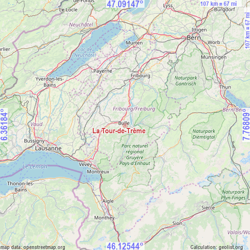
La Tour-de-Trême GPS coordinates[2]
46° 36' 38.196" North, 7° 3' 53.856" East
| Map corner | latitude | longitude |
|---|---|---|
| Upper-left | 47.09147°, | 6.36184° |
| Center: | 46.61061°, | 7.06496° |
| Lower-right: | 46.12544°, | 7.76809° |
| Map W x H: | 107.4×107.4 km | = 66.7×66.7mi |
| max Lat: | 47.76737° ⇑82% North |
| La Tour-de-Trême: | 46.61061° |
| min Lat: | ⇓18% South 45.83203° |
| min Long | La Tour-de-Trê | max Long |
| 5.97153° | 7.06496° | 10.44624° |
| W 14%⇐ | ⇒86% E |
Elevation
Elevation of La Tour-de-Trême is 747 m = 2451 ft, and this is 188.8 m = 619 ft above average elevation for this country.
| Max E: |
1845 m = 6053 ft | 14.3% |
| La Tour-de-Trême | 747 m 2451 ft | |
| Avg. | 558.2 m = 1831 ft | |
Min E: |
197 m = 646 ft | 85.7% |
See also: Switzerland elevation on elevation.city.
Geographical zone
La Tour-de-Trême is located in North temperate zone (between Tropic of Cancer and the Arctic Circle). Distance of this North polar circle is 2218.6 km =1378.6 mi to North.| Distance of | km | miles | from La Tour-de-Trême |
|---|---|---|---|
| North Pole | 4824.4 | 2997.7 | to North |
| Arctic Circle | 2218.6 | 1378.6 | to North |
| Tropic Cancer | 2576.7 | 1601.1 | to South |
| Equator | 5182.6 | 3220.3 | to South |


Nearby cities:
15 places around La Tour-de-Trême: (largest is in red/bold)
• Albeuve
10.4 km =6.5 mi,  183°
183°
• Broc
2.7 km =1.7 mi,  103°
103°
• Bulle
1 km =0.6 mi,  323°
323°
• Charmey
7.7 km =4.8 mi,  82°
82°
• Enney
5.1 km =3.2 mi,  163°
163°
• Grandvillard
8.1 km =5 mi,  168°
168°
• Gruyères
3.3 km =2.1 mi, 156°
• Hauteville
7.5 km =4.7 mi,  27°
27°
• Marsens
5.1 km =3.2 mi,  355°
355°
• Pont-la-Ville
10.3 km =6.4 mi,  19°
19°
• Riaz
3.5 km =2.2 mi, 356°
• Sorens
6.6 km =4.1 mi,  351°
351°
• Sâles
7.5 km =4.7 mi,  290°
290°
• Vaulruz
6 km =3.7 mi,  281°
281°
• Vuadens
3.7 km =2.3 mi, 278°
Sources, notices
• [Note1] Compared only with cities in Switzerland existing in our database
• [Src1] Map data: © OpenStreetMap contributors (CC-BY-SA)
• [Src2] Other city data from geonames.org with taken over terms of usage.
• [Src3] Geographical zone / Annual Mean Temperature by Robert A. Rohde @ Wikipedia
