Saint-Gingolph geodata
Saint-Gingolph (Valais) is a populated place; located in Switzerland in Europe/Zurich (GMT+2) time zone. With population of 721 people, there are 1571 cities with bigger population in this country. Compared to other cities in Switzerland, 88.2% of cities are located further ↑North; 91.5% of cities are located further →East and 91.1% of cities have higher elevation than Saint-Gingolph. Note1


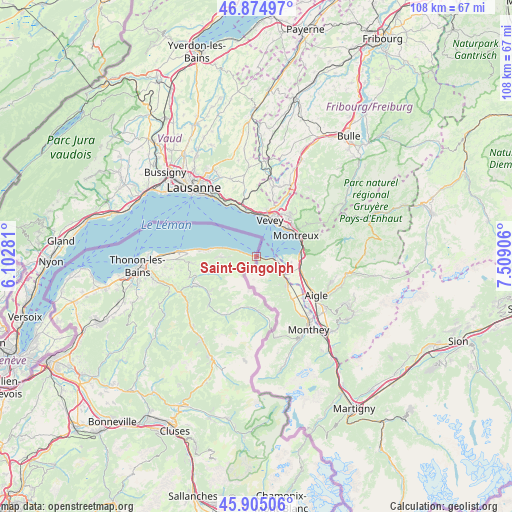
Saint-Gingolph GPS coordinates[2]
46° 23' 31.812" North, 6° 48' 21.384" East
| Map corner | latitude | longitude |
|---|---|---|
| Upper-left | 46.87497°, | 6.10281° |
| Center: | 46.39217°, | 6.80594° |
| Lower-right: | 45.90506°, | 7.50906° |
| Map W x H: | 107.8×107.8 km | = 67×67mi |
| max Lat: | 47.76737° ⇑88.2% North |
| Saint-Gingolph: | 46.39217° |
| min Lat: | ⇓11.8% South 45.83203° |
| min Long | Saint-Gingolph | max Long |
| 5.97153° | 6.80594° | 10.44624° |
| W 8.5%⇐ | ⇒91.5% E |
Elevation
Elevation of Saint-Gingolph is 389 m = 1276 ft, and this is 169.2 m = 555 ft below average elevation for this country.
| Max E: |
1845 m = 6053 ft | 91.1% |
| Avg. | 558.2 m = 1831 ft | |
| Saint-Gingolph | 389 m = 1276 ft | |
Min E: |
197 m = 646 ft | 8.9% |
See also: Switzerland elevation on elevation.city.
Geographical zone
Saint-Gingolph is located in North temperate zone (between Tropic of Cancer and the Arctic Circle). Distance of this North polar circle is 2242.8 km =1393.6 mi to North.| Distance of | km | miles | from Saint-Gingolph |
|---|---|---|---|
| North Pole | 4848.7 | 3012.8 | to North |
| Arctic Circle | 2242.8 | 1393.6 | to North |
| Tropic Cancer | 2552.4 | 1586 | to South |
| Equator | 5158.3 | 3205.2 | to South |


Nearby cities:
15 places around Saint-Gingolph: (largest is in red/bold)
• Blonay
10.9 km =6.8 mi,  39°
39°
• Chardonne
9.5 km =5.9 mi,  9°
9°
• Chexbres
10.2 km =6.3 mi,  347°
347°
• Jongny
10 km =6.2 mi,  15°
15°
• La Tour-de-Peilz
7.9 km =4.9 mi,  30°
30°
• Le Bouveret
4.2 km =2.6 mi,  103°
103°
• Montreux
9.3 km =5.8 mi,  60°
60°
• Roche
10.3 km =6.4 mi,  109°
109°
• Saint Saphorin
9.1 km =5.7 mi,  355°
355°
• St-Légier-La Chiésaz
10.3 km =6.4 mi, 30°
• Tanay
5.6 km =3.5 mi,  160°
160°
• Vevey
8.4 km =5.2 mi, 20°
• Veytaux
10.1 km =6.3 mi,  71°
71°
• Villeneuve
9.3 km =5.8 mi,  85°
85°
• Vouvry
8.8 km =5.5 mi,  133°
133°
Sources, notices
• [Note1] Compared only with cities in Switzerland existing in our database
• [Src1] Map data: © OpenStreetMap contributors (CC-BY-SA)
• [Src2] Other city data from geonames.org with taken over terms of usage.
• [Src3] Geographical zone / Annual Mean Temperature by Robert A. Rohde @ Wikipedia
