Chexbres geodata
Chexbres (Vaud) is a populated place; located in Switzerland in Europe/Zurich (GMT+2) time zone. With population of 2,133 people, there are 799 cities with bigger population in this country. Compared to other cities in Switzerland, 86.1% of cities are located further ↑North; 91.9% of cities are located further →East and 69.4% of cities have lower elevation than Chexbres. Note1


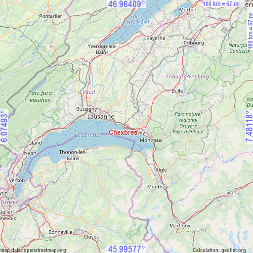
Chexbres GPS coordinates[2]
46° 28' 55.488" North, 6° 46' 40.98" East
| Map corner | latitude | longitude |
|---|---|---|
| Upper-left | 46.96409°, | 6.07493° |
| Center: | 46.48208°, | 6.77805° |
| Lower-right: | 45.99577°, | 7.48118° |
| Map W x H: | 107.7×107.7 km | = 66.9×66.9mi |
| max Lat: | 47.76737° ⇑86.1% North |
| Chexbres: | 46.48208° |
| min Lat: | ⇓13.9% South 45.83203° |
| min Long | Chexbres | max Long |
| 5.97153° | 6.77805° | 10.44624° |
| W 8.1%⇐ | ⇒91.9% E |
Elevation
Elevation of Chexbres is 570 m = 1870 ft, and this is 11.8 m = 39 ft above average elevation for this country.
| Max E: |
1845 m = 6053 ft | 30.6% |
| Chexbres | 570 m 1870 ft | |
| Avg. | 558.2 m = 1831 ft | |
Min E: |
197 m = 646 ft | 69.4% |
See also: Switzerland elevation on elevation.city.
Geographical zone
Chexbres is located in North temperate zone (between Tropic of Cancer and the Arctic Circle). Distance of this North polar circle is 2232.9 km =1387.5 mi to North.| Distance of | km | miles | from Chexbres |
|---|---|---|---|
| North Pole | 4838.7 | 3006.6 | to North |
| Arctic Circle | 2232.9 | 1387.5 | to North |
| Tropic Cancer | 2562.4 | 1592.2 | to South |
| Equator | 5168.3 | 3211.4 | to South |


Nearby cities:
15 places around Chexbres: (largest is in red/bold)
• Attalens
6.1 km =3.8 mi,  64°
64°
• Belmont-sur-Lausanne
8.8 km =5.5 mi,  297°
297°
• Blonay
9.2 km =5.7 mi,  99°
99°
• Chardonne
3.8 km =2.4 mi, 99°
• Cully
3.8 km =2.4 mi,  281°
281°
• Jongny
4.8 km =3 mi,  94°
94°
• La Tour-de-Peilz
7 km =4.3 mi,  117°
117°
• Lutry
7.4 km =4.6 mi,  287°
287°
• Palézieux
8.2 km =5.1 mi,  35°
35°
• Paudex
8.8 km =5.5 mi, 287°
• Puidoux
2.1 km =1.3 mi,  9°
9°
• Saint Saphorin
1.7 km =1.1 mi,  125°
125°
• Savigny
7.2 km =4.5 mi,  330°
330°
• St-Légier-La Chiésaz
7.4 km =4.6 mi, 98°
• Vevey
5.4 km =3.4 mi,  112°
112°
Sources, notices
• [Note1] Compared only with cities in Switzerland existing in our database
• [Src1] Map data: © OpenStreetMap contributors (CC-BY-SA)
• [Src2] Other city data from geonames.org with taken over terms of usage.
• [Src3] Geographical zone / Annual Mean Temperature by Robert A. Rohde @ Wikipedia
