La Tour-de-Peilz geodata
La Tour-de-Peilz (Vaud) is a populated place; located in Switzerland in Europe/Zurich (GMT+2) time zone. With population of 10,522 people, there are 133 cities with bigger population in this country. Compared to other cities in Switzerland, 87.2% of cities are located further ↑North; 90.4% of cities are located further →East and 91.7% of cities have higher elevation than La Tour-de-Peilz. Note1
Administrative division(s):
- Level 1: Vaud
- Level 2: Riviera-Pays-d'Enhaut District
- Level 3: La Tour-de-Peilz


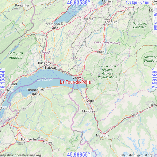
La Tour-de-Peilz GPS coordinates[2]
46° 27' 11.232" North, 6° 51' 30.816" East
| Map corner | latitude | longitude |
|---|---|---|
| Upper-left | 46.93538°, | 6.15544° |
| Center: | 46.45312°, | 6.85856° |
| Lower-right: | 45.96655°, | 7.56169° |
| Map W x H: | 107.7×107.7 km | = 66.9×66.9mi |
| max Lat: | 47.76737° ⇑87.2% North |
| La Tour-de-Peilz: | 46.45312° |
| min Lat: | ⇓12.8% South 45.83203° |
| min Long | La Tour-de-Peil | max Long |
| 5.97153° | 6.85856° | 10.44624° |
| W 9.6%⇐ | ⇒90.4% E |
Elevation
Elevation of La Tour-de-Peilz is 387 m = 1270 ft, and this is 171.2 m = 562 ft below average elevation for this country.
| Max E: |
1845 m = 6053 ft | 91.7% |
| Avg. | 558.2 m = 1831 ft | |
| La Tour-de-Peilz | 387 m = 1270 ft | |
Min E: |
197 m = 646 ft | 8.3% |
See also: Switzerland elevation on elevation.city.
Geographical zone
La Tour-de-Peilz is located in North temperate zone (between Tropic of Cancer and the Arctic Circle). Distance of this North polar circle is 2236.1 km =1389.4 mi to North.| Distance of | km | miles | from La Tour-de-Peilz |
|---|---|---|---|
| North Pole | 4842 | 3008.7 | to North |
| Arctic Circle | 2236.1 | 1389.4 | to North |
| Tropic Cancer | 2559.2 | 1590.2 | to South |
| Equator | 5165.1 | 3209.4 | to South |


Nearby cities:
15 places around La Tour-de-Peilz: (largest is in red/bold)
• Attalens
5.9 km =3.7 mi,  353°
353°
• Blonay
3.3 km =2.1 mi,  60°
60°
• Caux
6.5 km =4 mi,  110°
110°
• Chardonne
3.6 km =2.2 mi,  317°
317°
• Chexbres
7 km =4.3 mi,  297°
297°
• Jongny
3.2 km =2 mi,  334°
334°
• Le Bouveret
7.8 km =4.8 mi,  179°
179°
• Montreux
4.6 km =2.9 mi,  118°
118°
• Puidoux
7.9 km =4.9 mi,  312°
312°
• Saint Saphorin
5.3 km =3.3 mi, 295°
• Saint-Gingolph
7.9 km =4.9 mi,  210°
210°
• St-Légier-La Chiésaz
2.4 km =1.5 mi,  28°
28°
• Vevey
1.6 km =1 mi, 313°
• Veytaux
6.5 km =4 mi, 122°
• Villeneuve
8 km =5 mi,  139°
139°
Sources, notices
• [Note1] Compared only with cities in Switzerland existing in our database
• [Src1] Map data: © OpenStreetMap contributors (CC-BY-SA)
• [Src2] Other city data from geonames.org with taken over terms of usage.
• [Src3] Geographical zone / Annual Mean Temperature by Robert A. Rohde @ Wikipedia
