St-Légier-La Chiésaz geodata
St-Légier-La Chiésaz (Vaud) is a seat of a third-order administrative division; located in Switzerland in Europe/Zurich (GMT+2) time zone. In our database, there are 1823 cities with bigger population. Compared to other cities in Switzerland, 86.5% of cities are located further ↑North; 90.1% of cities are located further →East and 69.1% of cities have lower elevation than St-Légier-La Chiésaz. Note1
Administrative division(s):
- Level 1: Vaud
- Level 2: Riviera-Pays-d'Enhaut District
- Level 3: Saint-Légier-La Chiésaz


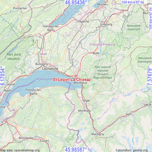
St-Légier-La Chiésaz GPS coordinates[2]
46° 28' 20.172" North, 6° 52' 25.176" East
| Map corner | latitude | longitude |
|---|---|---|
| Upper-left | 46.95436°, | 6.17054° |
| Center: | 46.47227°, | 6.87366° |
| Lower-right: | 45.98587°, | 7.57679° |
| Map W x H: | 107.7×107.7 km | = 66.9×66.9mi |
| max Lat: | 47.76737° ⇑86.5% North |
| St-Légier-La Chiésaz: | 46.47227° |
| min Lat: | ⇓13.5% South 45.83203° |
| min Long | St-Légier-La C | max Long |
| 5.97153° | 6.87366° | 10.44624° |
| W 9.9%⇐ | ⇒90.1% E |
Elevation
Elevation of St-Légier-La Chiésaz is 569 m = 1867 ft, and this is 10.8 m = 35 ft above average elevation for this country.
| Max E: |
1845 m = 6053 ft | 30.9% |
| St-Légier-La Chiésaz | 569 m 1867 ft | |
| Avg. | 558.2 m = 1831 ft | |
Min E: |
197 m = 646 ft | 69.1% |
See also: Switzerland elevation on elevation.city.
Geographical zone
St-Légier-La Chiésaz is located in North temperate zone (between Tropic of Cancer and the Arctic Circle). Distance of this North polar circle is 2233.9 km =1388.1 mi to North.| Distance of | km | miles | from St-Légier-La Chiésaz |
|---|---|---|---|
| North Pole | 4839.8 | 3007.3 | to North |
| Arctic Circle | 2233.9 | 1388.1 | to North |
| Tropic Cancer | 2561.3 | 1591.5 | to South |
| Equator | 5167.2 | 3210.7 | to South |


Nearby cities:
15 places around St-Légier-La Chiésaz: (largest is in red/bold)
• Attalens
4.1 km =2.5 mi,  334°
334°
• Blonay
1.8 km =1.1 mi,  106°
106°
• Caux
6.7 km =4.2 mi,  131°
131°
• Chardonne
3.6 km =2.2 mi,  277°
277°
• Chexbres
7.4 km =4.6 mi, 278°
• Châtel-Saint-Denis
6.4 km =4 mi,  18°
18°
• Jongny
2.6 km =1.6 mi,  286°
286°
• La Tour-de-Peilz
2.4 km =1.5 mi,  208°
208°
• Maracon
8.7 km =5.4 mi,  359°
359°
• Montreux
5.2 km =3.2 mi,  146°
146°
• Palézieux
8.2 km =5.1 mi,  341°
341°
• Puidoux
7.7 km =4.8 mi, 294°
• Saint Saphorin
5.9 km =3.7 mi,  271°
271°
• Vevey
2.5 km =1.6 mi,  245°
245°
• Veytaux
7.1 km =4.4 mi,  142°
142°
Sources, notices
• [Note1] Compared only with cities in Switzerland existing in our database
• [Src1] Map data: © OpenStreetMap contributors (CC-BY-SA)
• [Src2] Other city data from geonames.org with taken over terms of usage.
• [Src3] Geographical zone / Annual Mean Temperature by Robert A. Rohde @ Wikipedia
