Pampigny geodata
Pampigny (Vaud) is a seat of a third-order administrative division; located in Switzerland in Europe/Zurich (GMT+2) time zone. With population of 843 people, there are 1465 cities with bigger population in this country. Compared to other cities in Switzerland, 83% of cities are located further ↑North; 96.2% of cities are located further →East and 79.8% of cities have lower elevation than Pampigny. Note1


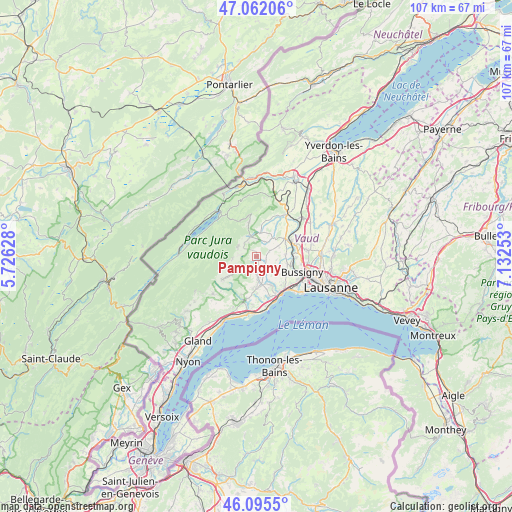
Pampigny GPS coordinates[2]
46° 34' 51.348" North, 6° 25' 45.876" East
| Map corner | latitude | longitude |
|---|---|---|
| Upper-left | 47.06206°, | 5.72628° |
| Center: | 46.58093°, | 6.42941° |
| Lower-right: | 46.0955°, | 7.13253° |
| Map W x H: | 107.5×107.5 km | = 66.8×66.8mi |
| max Lat: | 47.76737° ⇑83% North |
| Pampigny: | 46.58093° |
| min Lat: | ⇓17% South 45.83203° |
| min Long | Pampigny | max Long |
| 5.97153° | 6.42941° | 10.44624° |
| W 3.8%⇐ | ⇒96.2% E |
Elevation
Elevation of Pampigny is 658 m = 2159 ft, and this is 99.8 m = 327 ft above average elevation for this country.
| Max E: |
1845 m = 6053 ft | 20.2% |
| Pampigny | 658 m 2159 ft | |
| Avg. | 558.2 m = 1831 ft | |
Min E: |
197 m = 646 ft | 79.8% |
See also: Switzerland elevation on elevation.city.
Geographical zone
Pampigny is located in North temperate zone (between Tropic of Cancer and the Arctic Circle). Distance of this North polar circle is 2221.9 km =1380.6 mi to North.| Distance of | km | miles | from Pampigny |
|---|---|---|---|
| North Pole | 4827.7 | 2999.8 | to North |
| Arctic Circle | 2221.9 | 1380.6 | to North |
| Tropic Cancer | 2573.4 | 1599 | to South |
| Equator | 5179.3 | 3218.3 | to South |


Nearby cities:
15 places around Pampigny: (largest is in red/bold)
• Apples
3.2 km =2 mi,  180°
180°
• Ballens
5.2 km =3.2 mi,  236°
236°
• Berolle
7.6 km =4.7 mi,  250°
250°
• Chavannes-le-Veyron
3.3 km =2.1 mi,  29°
29°
• Colombier
4.2 km =2.6 mi,  128°
128°
• Cossonay
7 km =4.3 mi,  57°
57°
• Cuarnens
5 km =3.1 mi,  6°
6°
• Gollion
6.2 km =3.9 mi,  85°
85°
• Grancy
2.9 km =1.8 mi, 64°
• La Chaux
5.2 km =3.2 mi,  39°
39°
• Mauraz
2.8 km =1.7 mi,  346°
346°
• Mollens
5.1 km =3.2 mi,  265°
265°
• Montricher
4.5 km =2.8 mi,  297°
297°
• Vufflens-le-Château
6.9 km =4.3 mi,  151°
151°
• Yens
6.9 km =4.3 mi,  186°
186°
Sources, notices
• [Note1] Compared only with cities in Switzerland existing in our database
• [Src1] Map data: © OpenStreetMap contributors (CC-BY-SA)
• [Src2] Other city data from geonames.org with taken over terms of usage.
• [Src3] Geographical zone / Annual Mean Temperature by Robert A. Rohde @ Wikipedia
