Cuarnens geodata
Cuarnens (Vaud) is a seat of a third-order administrative division; located in Switzerland in Europe/Zurich (GMT+2) time zone. In our database, there are 1823 cities with bigger population. Compared to other cities in Switzerland, 81.2% of cities are located further ↑North; 96.2% of cities are located further →East and 76.9% of cities have lower elevation than Cuarnens. Note1


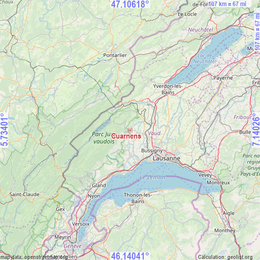
Cuarnens GPS coordinates[2]
46° 37' 31.62" North, 6° 26' 13.668" East
| Map corner | latitude | longitude |
|---|---|---|
| Upper-left | 47.10618°, | 5.73401° |
| Center: | 46.62545°, | 6.43713° |
| Lower-right: | 46.14041°, | 7.14026° |
| Map W x H: | 107.4×107.4 km | = 66.7×66.7mi |
| max Lat: | 47.76737° ⇑81.2% North |
| Cuarnens: | 46.62545° |
| min Lat: | ⇓18.8% South 45.83203° |
| min Long | Cuarnens | max Long |
| 5.97153° | 6.43713° | 10.44624° |
| W 3.8%⇐ | ⇒96.2% E |
Elevation
Elevation of Cuarnens is 632 m = 2073 ft, and this is 73.8 m = 242 ft above average elevation for this country.
| Max E: |
1845 m = 6053 ft | 23.1% |
| Cuarnens | 632 m 2073 ft | |
| Avg. | 558.2 m = 1831 ft | |
Min E: |
197 m = 646 ft | 76.9% |
See also: Switzerland elevation on elevation.city.
Geographical zone
Cuarnens is located in North temperate zone (between Tropic of Cancer and the Arctic Circle). Distance of this North polar circle is 2216.9 km =1377.5 mi to North.| Distance of | km | miles | from Cuarnens |
|---|---|---|---|
| North Pole | 4822.8 | 2996.7 | to North |
| Arctic Circle | 2216.9 | 1377.5 | to North |
| Tropic Cancer | 2578.3 | 1602.1 | to South |
| Equator | 5184.3 | 3221.4 | to South |


Nearby cities:
15 places around Cuarnens: (largest is in red/bold)
• Chavannes-le-Veyron
2.3 km =1.4 mi,  152°
152°
• Chevilly
3.6 km =2.2 mi,  57°
57°
• Cossonay
5.4 km =3.4 mi,  103°
103°
• Ferreyres
5.2 km =3.2 mi,  45°
45°
• Gollion
7.1 km =4.4 mi,  128°
128°
• Grancy
4.2 km =2.6 mi, 151°
• La Chaux
2.8 km =1.7 mi,  109°
109°
• La Sarraz
6.7 km =4.2 mi, 56°
• Mauraz
2.5 km =1.6 mi,  209°
209°
• Moiry
2.9 km =1.8 mi,  25°
25°
• Mollens
7.8 km =4.8 mi,  226°
226°
• Montricher
5.4 km =3.4 mi,  238°
238°
• Pampigny
5 km =3.1 mi,  186°
186°
• Penthalaz
6.9 km =4.3 mi, 103°
• Pompaples
7.2 km =4.5 mi, 50°
Sources, notices
• [Note1] Compared only with cities in Switzerland existing in our database
• [Src1] Map data: © OpenStreetMap contributors (CC-BY-SA)
• [Src2] Other city data from geonames.org with taken over terms of usage.
• [Src3] Geographical zone / Annual Mean Temperature by Robert A. Rohde @ Wikipedia
