Vufflens-le-Château geodata
Vufflens-le-Château (Vaud) is a populated locality; located in Switzerland in Europe/Zurich (GMT+2) time zone. With population of 700 people, there are 1598 cities with bigger population in this country. Compared to other cities in Switzerland, 84.7% of cities are located further ↑North; 95.8% of cities are located further →East and 53.2% of cities have lower elevation than Vufflens-le-Château. Note1


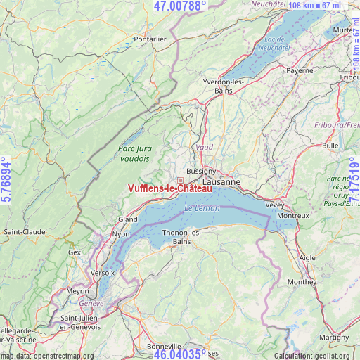
Vufflens-le-Château GPS coordinates[2]
46° 31' 34.572" North, 6° 28' 19.416" East
| Map corner | latitude | longitude |
|---|---|---|
| Upper-left | 47.00788°, | 5.76894° |
| Center: | 46.52627°, | 6.47206° |
| Lower-right: | 46.04035°, | 7.17519° |
| Map W x H: | 107.6×107.6 km | = 66.9×66.9mi |
| max Lat: | 47.76737° ⇑84.7% North |
| Vufflens-le-Château: | 46.52627° |
| min Lat: | ⇓15.3% South 45.83203° |
| min Long | Vufflens-le-Ch� | max Long |
| 5.97153° | 6.47206° | 10.44624° |
| W 4.2%⇐ | ⇒95.8% E |
Elevation
Elevation of Vufflens-le-Château is 488 m = 1601 ft, and this is 70.2 m = 230 ft below average elevation for this country.
| Max E: |
1845 m = 6053 ft | 46.8% |
| Avg. | 558.2 m = 1831 ft | |
| Vufflens-le-Château | 488 m = 1601 ft | |
Min E: |
197 m = 646 ft | 53.2% |
See also: Switzerland elevation on elevation.city.
Geographical zone
Vufflens-le-Château is located in North temperate zone (between Tropic of Cancer and the Arctic Circle). Distance of this North polar circle is 2227.9 km =1384.4 mi to North.| Distance of | km | miles | from Vufflens-le-Château |
|---|---|---|---|
| North Pole | 4833.8 | 3003.6 | to North |
| Arctic Circle | 2227.9 | 1384.4 | to North |
| Tropic Cancer | 2567.3 | 1595.2 | to South |
| Equator | 5173.2 | 3214.5 | to South |


Nearby cities:
15 places around Vufflens-le-Château: (largest is in red/bold)
• Apples
4.4 km =2.7 mi,  311°
311°
• Aubonne
7.1 km =4.4 mi,  240°
240°
• Bussigny
7 km =4.3 mi,  66°
66°
• Chavannes
7.6 km =4.7 mi,  86°
86°
• Colombier
3.4 km =2.1 mi,  0°
0°
• Ecublens
6.9 km =4.3 mi, 87°
• Gollion
7.2 km =4.5 mi,  23°
23°
• Grancy
7.4 km =4.6 mi,  355°
355°
• Lully VD
2.4 km =1.5 mi,  193°
193°
• Morges
2.6 km =1.6 mi,  129°
129°
• Pampigny
6.9 km =4.3 mi,  331°
331°
• Préverenges
4.3 km =2.7 mi,  101°
101°
• Saint-Livres
6.8 km =4.2 mi,  252°
252°
• Saint-Prex
5.3 km =3.3 mi, 190°
• Yens
4.2 km =2.6 mi,  258°
258°
Sources, notices
• [Note1] Compared only with cities in Switzerland existing in our database
• [Src1] Map data: © OpenStreetMap contributors (CC-BY-SA)
• [Src2] Other city data from geonames.org with taken over terms of usage.
• [Src3] Geographical zone / Annual Mean Temperature by Robert A. Rohde @ Wikipedia
