Kandersteg geodata
Kandersteg (Bern) is a populated place; located in Switzerland in Europe/Zurich (GMT+2) time zone. With population of 1,123 people, there are 1250 cities with bigger population in this country. Compared to other cities in Switzerland, 85.9% of cities are located further ↑North; 69.1% of cities are located further →East and 97.1% of cities have lower elevation than Kandersteg. Note1
Administrative division(s):
- Level 1: Bern
- Level 2: Frutigen-Niedersimmental District
- Level 3: Kandersteg


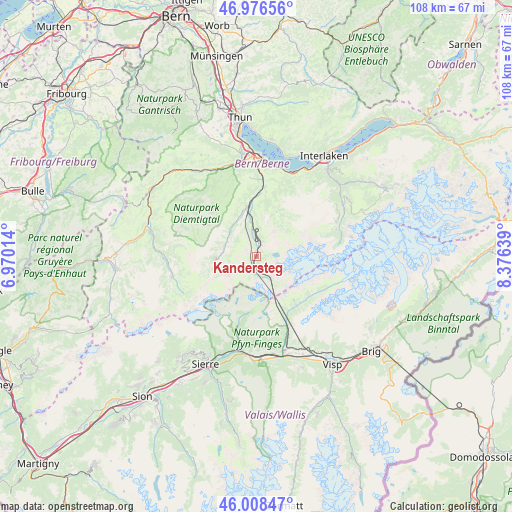
Kandersteg GPS coordinates[2]
46° 29' 40.812" North, 7° 40' 23.736" East
| Map corner | latitude | longitude |
|---|---|---|
| Upper-left | 46.97656°, | 6.97014° |
| Center: | 46.49467°, | 7.67326° |
| Lower-right: | 46.00847°, | 8.37639° |
| Map W x H: | 107.6×107.6 km | = 66.9×66.9mi |
| max Lat: | 47.76737° ⇑85.9% North |
| Kandersteg: | 46.49467° |
| min Lat: | ⇓14.1% South 45.83203° |
| min Long | Kandersteg | max Long |
| 5.97153° | 7.67326° | 10.44624° |
| W 30.9%⇐ | ⇒69.1% E |
Elevation
Elevation of Kandersteg is 1172 m = 3845 ft, and this is 613.8 m = 2014 ft above average elevation for this country.
| Max E: |
1845 m = 6053 ft | 2.9% |
| Kandersteg | 1172 m 3845 ft | |
| Avg. | 558.2 m = 1831 ft | |
Min E: |
197 m = 646 ft | 97.1% |
See also: Switzerland elevation on elevation.city.
Geographical zone
Kandersteg is located in North temperate zone (between Tropic of Cancer and the Arctic Circle). Distance of this North polar circle is 2231.5 km =1386.6 mi to North.| Distance of | km | miles | from Kandersteg |
|---|---|---|---|
| North Pole | 4837.3 | 3005.8 | to North |
| Arctic Circle | 2231.5 | 1386.6 | to North |
| Tropic Cancer | 2563.8 | 1593.1 | to South |
| Equator | 5169.7 | 3212.3 | to South |


Nearby cities:
15 places around Kandersteg: (largest is in red/bold)
• Adelboden
8.7 km =5.4 mi,  267°
267°
• Aeschi b. Spiez
18.3 km =11.4 mi,  5°
5°
• Diemtigen
19.1 km =11.9 mi,  334°
334°
• Erlenbach im Simmental
20.5 km =12.7 mi, 333°
• Frutigen
10.5 km =6.5 mi,  349°
349°
• Gampel
20.6 km =12.8 mi,  165°
165°
• Kandergrund
7.6 km =4.7 mi, 351°
• Krattigen
19 km =11.8 mi, 12°
• Leissigen
19.4 km =12.1 mi,  23°
23°
• Lenk
18.1 km =11.2 mi,  257°
257°
• Leuk
19.9 km =12.4 mi,  188°
188°
• Leukerbad
13.3 km =8.3 mi,  195°
195°
• Varen
20.2 km =12.6 mi, 194°
• Wiler
13.1 km =8.1 mi,  140°
140°
• Wimmis
20.3 km =12.6 mi, 352°
Sources, notices
• [Note1] Compared only with cities in Switzerland existing in our database
• [Src1] Map data: © OpenStreetMap contributors (CC-BY-SA)
• [Src2] Other city data from geonames.org with taken over terms of usage.
• [Src3] Geographical zone / Annual Mean Temperature by Robert A. Rohde @ Wikipedia
