Adelboden geodata
Adelboden (Bern) is a populated place; located in Switzerland in Europe/Zurich (GMT+2) time zone. With population of 3,541 people, there are 501 cities with bigger population in this country. Compared to other cities in Switzerland, 85.9% of cities are located further ↑North; 73.4% of cities are located further →East and 98.1% of cities have lower elevation than Adelboden. Note1
Administrative division(s):
- Level 1: Bern
- Level 2: Frutigen-Niedersimmental District
- Level 3: Adelboden


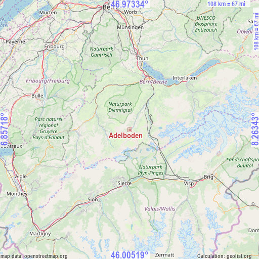
Adelboden GPS coordinates[2]
46° 29' 29.112" North, 7° 33' 37.116" East
| Map corner | latitude | longitude |
|---|---|---|
| Upper-left | 46.97334°, | 6.85718° |
| Center: | 46.49142°, | 7.56031° |
| Lower-right: | 46.00519°, | 8.26343° |
| Map W x H: | 107.6×107.6 km | = 66.9×66.9mi |
| max Lat: | 47.76737° ⇑85.9% North |
| Adelboden: | 46.49142° |
| min Lat: | ⇓14.1% South 45.83203° |
| min Long | Adelboden | max Long |
| 5.97153° | 7.56031° | 10.44624° |
| W 26.6%⇐ | ⇒73.4% E |
Elevation
Elevation of Adelboden is 1328 m = 4357 ft, and this is 769.8 m = 2526 ft above average elevation for this country.
| Max E: |
1845 m = 6053 ft | 1.9% |
| Adelboden | 1328 m 4357 ft | |
| Avg. | 558.2 m = 1831 ft | |
Min E: |
197 m = 646 ft | 98.1% |
See also: Switzerland elevation on elevation.city.
Geographical zone
Adelboden is located in North temperate zone (between Tropic of Cancer and the Arctic Circle). Distance of this North polar circle is 2231.8 km =1386.8 mi to North.| Distance of | km | miles | from Adelboden |
|---|---|---|---|
| North Pole | 4837.7 | 3006 | to North |
| Arctic Circle | 2231.8 | 1386.8 | to North |
| Tropic Cancer | 2563.4 | 1592.8 | to South |
| Equator | 5169.4 | 3212.1 | to South |


Nearby cities:
15 places around Adelboden: (largest is in red/bold)
• Boltigen
20 km =12.4 mi,  319°
319°
• Diemtigen
17.6 km =10.9 mi,  1°
1°
• Därstetten
19.4 km =12.1 mi,  344°
344°
• Erlenbach im Simmental
18.8 km =11.7 mi,  358°
358°
• Frutigen
12.6 km =7.8 mi,  32°
32°
• Kandergrund
10.9 km =6.8 mi,  43°
43°
• Kandersteg
8.7 km =5.4 mi,  87°
87°
• Lenk
9.7 km =6 mi,  247°
247°
• Leukerbad
13.5 km =8.4 mi,  157°
157°
• Miège
20.1 km =12.5 mi,  182°
182°
• Salgesch
20 km =12.4 mi, 177°
• Sankt Stephan
12.7 km =7.9 mi,  278°
278°
• Varen
19.6 km =12.2 mi,  169°
169°
• Wiler
19.6 km =12.2 mi,  120°
120°
• Zweisimmen
16 km =9.9 mi,  296°
296°
Sources, notices
• [Note1] Compared only with cities in Switzerland existing in our database
• [Src1] Map data: © OpenStreetMap contributors (CC-BY-SA)
• [Src2] Other city data from geonames.org with taken over terms of usage.
• [Src3] Geographical zone / Annual Mean Temperature by Robert A. Rohde @ Wikipedia
