Unterschächen geodata
Unterschächen (Uri) is a populated place; located in Switzerland in Europe/Zurich (GMT+2) time zone. With population of 760 people, there are 1522 cities with bigger population in this country. Compared to other cities in Switzerland, 71.4% of cities are located further ↑North; 79.4% of cities are located further ←West and 94.8% of cities have lower elevation than Unterschächen. Note1


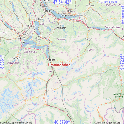
Unterschächen GPS coordinates[2]
46° 51' 46.116" North, 8° 46' 9.228" East
| Map corner | latitude | longitude |
|---|---|---|
| Upper-left | 47.34142°, | 8.0661° |
| Center: | 46.86281°, | 8.76923° |
| Lower-right: | 46.3799°, | 9.47235° |
| Map W x H: | 106.9×106.9 km | = 66.4×66.4mi |
| max Lat: | 47.76737° ⇑71.4% North |
| Unterschächen: | 46.86281° |
| min Lat: | ⇓28.6% South 45.83203° |
| min Long | Unterschächen | max Long |
| 5.97153° | 8.76923° | 10.44624° |
| W 79.4%⇐ | ⇒20.6% E |
Elevation
Elevation of Unterschächen is 1001 m = 3284 ft, and this is 442.8 m = 1453 ft above average elevation for this country.
| Max E: |
1845 m = 6053 ft | 5.2% |
| Unterschächen | 1001 m 3284 ft | |
| Avg. | 558.2 m = 1831 ft | |
Min E: |
197 m = 646 ft | 94.8% |
See also: Switzerland elevation on elevation.city.
Geographical zone
Unterschächen is located in North temperate zone (between Tropic of Cancer and the Arctic Circle). Distance of this North polar circle is 2190.5 km =1361.1 mi to North.| Distance of | km | miles | from Unterschächen |
|---|---|---|---|
| North Pole | 4796.4 | 2980.3 | to North |
| Arctic Circle | 2190.5 | 1361.1 | to North |
| Tropic Cancer | 2604.7 | 1618.5 | to South |
| Equator | 5210.7 | 3237.8 | to South |


Nearby cities:
15 places around Unterschächen: (largest is in red/bold)
• Altdorf
9.7 km =6 mi,  281°
281°
• Attinghausen
10.6 km =6.6 mi,  269°
269°
• Bauen
16.6 km =10.3 mi,  299°
299°
• Bürglen
8 km =5 mi, 280°
• Erstfeld
10.3 km =6.4 mi,  241°
241°
• Flüelen
12 km =7.5 mi,  292°
292°
• Gurtnellen
17.5 km =10.9 mi,  217°
217°
• Illgau
14.3 km =8.9 mi,  346°
346°
• Isenthal
16.7 km =10.4 mi, 288°
• Morschach
17.6 km =10.9 mi,  319°
319°
• Muotathal
12.7 km =7.9 mi,  358°
358°
• Schattdorf
8.7 km =5.4 mi, 271°
• Seedorf
11.8 km =7.3 mi, 280°
• Silenen
11 km =6.8 mi, 221°
• Spiringen
3.2 km =2 mi, 290°
Sources, notices
• [Note1] Compared only with cities in Switzerland existing in our database
• [Src1] Map data: © OpenStreetMap contributors (CC-BY-SA)
• [Src2] Other city data from geonames.org with taken over terms of usage.
• [Src3] Geographical zone / Annual Mean Temperature by Robert A. Rohde @ Wikipedia
