Carouge geodata
Carouge (Geneva) is a populated place; located in Switzerland in Europe/Zurich (GMT+2) time zone. With population of 19,344 people, there are 45 cities with bigger population in this country. Compared to other cities in Switzerland, 95.1% of cities are located further ↑North; 99.2% of cities are located further →East and 91.5% of cities have higher elevation than Carouge. Note1


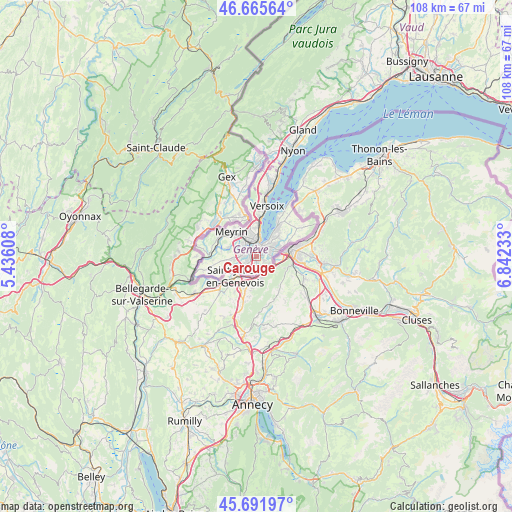
Carouge GPS coordinates[2]
46° 10' 51.456" North, 6° 8' 21.156" East
| Map corner | latitude | longitude |
|---|---|---|
| Upper-left | 46.66564°, | 5.43608° |
| Center: | 46.18096°, | 6.13921° |
| Lower-right: | 45.69197°, | 6.84233° |
| Map W x H: | 108.3×108.3 km | = 67.3×67.3mi |
| max Lat: | 47.76737° ⇑95.1% North |
| Carouge: | 46.18096° |
| min Lat: | ⇓4.9% South 45.83203° |
| min Long | Carouge | max Long |
| 5.97153° | 6.13921° | 10.44624° |
| W 0.8%⇐ | ⇒99.2% E |
Elevation
Elevation of Carouge is 388 m = 1273 ft, and this is 170.2 m = 558 ft below average elevation for this country.
| Max E: |
1845 m = 6053 ft | 91.5% |
| Avg. | 558.2 m = 1831 ft | |
| Carouge | 388 m = 1273 ft | |
Min E: |
197 m = 646 ft | 8.5% |
See also: Switzerland elevation on elevation.city.
Geographical zone
Carouge is located in North temperate zone (between Tropic of Cancer and the Arctic Circle). Distance of this North polar circle is 2266.3 km =1408.2 mi to North.| Distance of | km | miles | from Carouge |
|---|---|---|---|
| North Pole | 4872.2 | 3027.4 | to North |
| Arctic Circle | 2266.3 | 1408.2 | to North |
| Tropic Cancer | 2528.9 | 1571.4 | to South |
| Equator | 5134.8 | 3190.6 | to South |


Nearby cities:
15 places around Carouge: (largest is in red/bold)
• Bernex
4.9 km =3 mi,  264°
264°
• Chêne-Bougeries
4.1 km =2.5 mi,  61°
61°
• Chêne-Bourg
4.5 km =2.8 mi,  69°
69°
• Confignon
4.3 km =2.7 mi, 258°
• Genève
2.4 km =1.5 mi,  11°
11°
• Lancy
2.1 km =1.3 mi,  297°
297°
• Le Grand-Saconnex
5.8 km =3.6 mi,  346°
346°
• Les Avanchets
5.1 km =3.2 mi,  332°
332°
• Onex
2.9 km =1.8 mi,  276°
276°
• Plan-les-Ouates
2.3 km =1.4 mi,  230°
230°
• Thônex
4.7 km =2.9 mi,  80°
80°
• Troinex
2.1 km =1.3 mi,  162°
162°
• Vandœuvres
6.7 km =4.2 mi,  47°
47°
• Vernier
5.8 km =3.6 mi,  313°
313°
• Veyrier
3.8 km =2.4 mi,  114°
114°
Sources, notices
• [Note1] Compared only with cities in Switzerland existing in our database
• [Src1] Map data: © OpenStreetMap contributors (CC-BY-SA)
• [Src2] Other city data from geonames.org with taken over terms of usage.
• [Src3] Geographical zone / Annual Mean Temperature by Robert A. Rohde @ Wikipedia
