Canobbio geodata
Canobbio (Ticino) is a populated place; located in Switzerland in Europe/Zurich (GMT+2) time zone. With population of 1,869 people, there are 882 cities with bigger population in this country. Compared to other cities in Switzerland, 98.1% of cities are located further ↑North; 86.8% of cities are located further ←West and 84.6% of cities have higher elevation than Canobbio. Note1


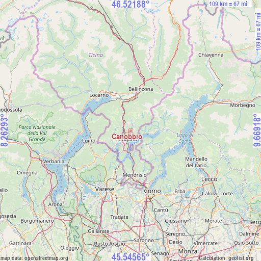
Canobbio GPS coordinates[2]
46° 2' 9.312" North, 8° 57' 57.78" East
| Map corner | latitude | longitude |
|---|---|---|
| Upper-left | 46.52188°, | 8.26293° |
| Center: | 46.03592°, | 8.96605° |
| Lower-right: | 45.54565°, | 9.66918° |
| Map W x H: | 108.5×108.5 km | = 67.4×67.4mi |
| max Lat: | 47.76737° ⇑98.1% North |
| Canobbio: | 46.03592° |
| min Lat: | ⇓1.9% South 45.83203° |
| min Long | Canobbio | max Long |
| 5.97153° | 8.96605° | 10.44624° |
| W 86.8%⇐ | ⇒13.2% E |
Elevation
Elevation of Canobbio is 411 m = 1348 ft, and this is 147.2 m = 483 ft below average elevation for this country.
| Max E: |
1845 m = 6053 ft | 84.6% |
| Avg. | 558.2 m = 1831 ft | |
| Canobbio | 411 m = 1348 ft | |
Min E: |
197 m = 646 ft | 15.4% |
See also: Switzerland elevation on elevation.city.
Geographical zone
Canobbio is located in North temperate zone (between Tropic of Cancer and the Arctic Circle). Distance of this North polar circle is 2282.5 km =1418.3 mi to North.| Distance of | km | miles | from Canobbio |
|---|---|---|---|
| North Pole | 4888.3 | 3037.4 | to North |
| Arctic Circle | 2282.5 | 1418.3 | to North |
| Tropic Cancer | 2512.8 | 1561.4 | to South |
| Equator | 5118.7 | 3180.6 | to South |


Nearby cities:
15 places around Canobbio: (largest is in red/bold)
• Agno
6.6 km =4.1 mi,  230°
230°
• Bioggio
4.9 km =3 mi,  239°
239°
• Cadempino
2.5 km =1.6 mi,  272°
272°
• Cadro
2 km =1.2 mi,  55°
55°
• Cagiallo
3.5 km =2.2 mi,  9°
9°
• Comano
0.8 km =0.5 mi, 273°
• Gravesano
3.7 km =2.3 mi,  280°
280°
• Lugano
2.9 km =1.8 mi,  189°
189°
• Massagno
3.1 km =1.9 mi,  213°
213°
• Montagnola
6.9 km =4.3 mi, 212°
• Pregassona
1.9 km =1.2 mi,  159°
159°
• Savosa
2.6 km =1.6 mi,  224°
224°
• Sorengo
4.8 km =3 mi, 207°
• Tesserete
3.6 km =2.2 mi,  358°
358°
• Viganello
2.5 km =1.6 mi,  175°
175°
Sources, notices
• [Note1] Compared only with cities in Switzerland existing in our database
• [Src1] Map data: © OpenStreetMap contributors (CC-BY-SA)
• [Src2] Other city data from geonames.org with taken over terms of usage.
• [Src3] Geographical zone / Annual Mean Temperature by Robert A. Rohde @ Wikipedia
