Boltigen geodata
Boltigen (Bern) is a populated place; located in Switzerland in Europe/Zurich (GMT+2) time zone. With population of 1,443 people, there are 1057 cities with bigger population in this country. Compared to other cities in Switzerland, 81% of cities are located further ↑North; 78.1% of cities are located further →East and 89.8% of cities have lower elevation than Boltigen. Note1


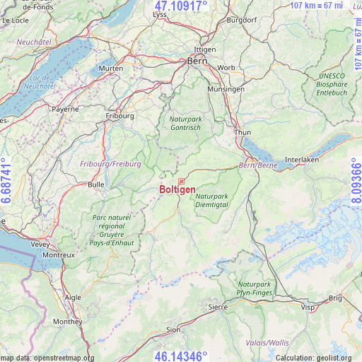
Boltigen GPS coordinates[2]
46° 37' 42.492" North, 7° 23' 25.944" East
| Map corner | latitude | longitude |
|---|---|---|
| Upper-left | 47.10917°, | 6.68741° |
| Center: | 46.62847°, | 7.39054° |
| Lower-right: | 46.14346°, | 8.09366° |
| Map W x H: | 107.4×107.4 km | = 66.7×66.7mi |
| max Lat: | 47.76737° ⇑81% North |
| Boltigen: | 46.62847° |
| min Lat: | ⇓19% South 45.83203° |
| min Long | Boltigen | max Long |
| 5.97153° | 7.39054° | 10.44624° |
| W 21.9%⇐ | ⇒78.1% E |
Elevation
Elevation of Boltigen is 815 m = 2674 ft, and this is 256.8 m = 843 ft above average elevation for this country.
| Max E: |
1845 m = 6053 ft | 10.2% |
| Boltigen | 815 m 2674 ft | |
| Avg. | 558.2 m = 1831 ft | |
Min E: |
197 m = 646 ft | 89.8% |
See also: Switzerland elevation on elevation.city.
Geographical zone
Boltigen is located in North temperate zone (between Tropic of Cancer and the Arctic Circle). Distance of this North polar circle is 2216.6 km =1377.3 mi to North.| Distance of | km | miles | from Boltigen |
|---|---|---|---|
| North Pole | 4822.5 | 2996.6 | to North |
| Arctic Circle | 2216.6 | 1377.3 | to North |
| Tropic Cancer | 2578.7 | 1602.3 | to South |
| Equator | 5184.6 | 3221.6 | to South |


Nearby cities:
15 places around Boltigen: (largest is in red/bold)
• Blumenstein
16.1 km =10 mi,  38°
38°
• Charmey
17.3 km =10.7 mi,  266°
266°
• Diemtigen
13.5 km =8.4 mi,  80°
80°
• Därstetten
8.4 km =5.2 mi,  65°
65°
• Erlenbach im Simmental
13 km =8.1 mi, 74°
• Guggisberg
16.2 km =10.1 mi,  343°
343°
• Jaun
9 km =5.6 mi,  257°
257°
• Oberschrot
15 km =9.3 mi,  326°
326°
• Plaffeien
14.9 km =9.3 mi, 327°
• Plasselb
15.9 km =9.9 mi,  318°
318°
• Rüschegg
16.8 km =10.4 mi,  0°
0°
• Sankt Stephan
13.4 km =8.3 mi,  178°
178°
• Uebeschi
17.5 km =10.9 mi,  46°
46°
• Wattenwil
18.1 km =11.2 mi,  29°
29°
• Zweisimmen
8.2 km =5.1 mi,  189°
189°
Sources, notices
• [Note1] Compared only with cities in Switzerland existing in our database
• [Src1] Map data: © OpenStreetMap contributors (CC-BY-SA)
• [Src2] Other city data from geonames.org with taken over terms of usage.
• [Src3] Geographical zone / Annual Mean Temperature by Robert A. Rohde @ Wikipedia
