Sankt Stephan geodata
Sankt Stephan (Bern) is a populated place; located in Switzerland in Europe/Zurich (GMT+2) time zone. With population of 1,352 people, there are 1104 cities with bigger population in this country. Compared to other cities in Switzerland, 85.3% of cities are located further ↑North; 78% of cities are located further →East and 95% of cities have lower elevation than Sankt Stephan. Note1
Administrative division(s):
- Level 1: Bern
- Level 2: Obersimmental-Saanen District
- Level 3: St. Stephan


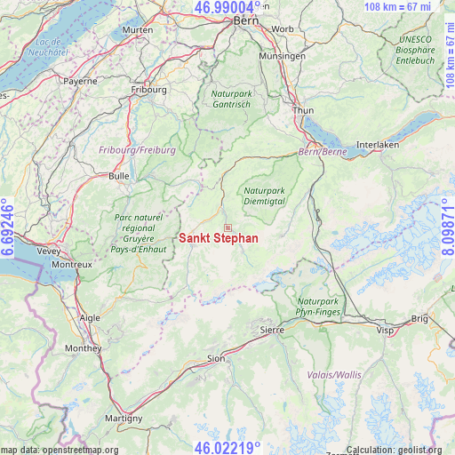
Sankt Stephan GPS coordinates[2]
46° 30' 29.772" North, 7° 23' 44.124" East
| Map corner | latitude | longitude |
|---|---|---|
| Upper-left | 46.99004°, | 6.69246° |
| Center: | 46.50827°, | 7.39559° |
| Lower-right: | 46.02219°, | 8.09871° |
| Map W x H: | 107.6×107.6 km | = 66.9×66.9mi |
| max Lat: | 47.76737° ⇑85.3% North |
| Sankt Stephan: | 46.50827° |
| min Lat: | ⇓14.7% South 45.83203° |
| min Long | Sankt Stephan | max Long |
| 5.97153° | 7.39559° | 10.44624° |
| W 22%⇐ | ⇒78% E |
Elevation
Elevation of Sankt Stephan is 1007 m = 3304 ft, and this is 448.8 m = 1472 ft above average elevation for this country.
| Max E: |
1845 m = 6053 ft | 5% |
| Sankt Stephan | 1007 m 3304 ft | |
| Avg. | 558.2 m = 1831 ft | |
Min E: |
197 m = 646 ft | 95% |
See also: Switzerland elevation on elevation.city.
Geographical zone
Sankt Stephan is located in North temperate zone (between Tropic of Cancer and the Arctic Circle). Distance of this North polar circle is 2229.9 km =1385.6 mi to North.| Distance of | km | miles | from Sankt Stephan |
|---|---|---|---|
| North Pole | 4835.8 | 3004.8 | to North |
| Arctic Circle | 2229.9 | 1385.6 | to North |
| Tropic Cancer | 2565.3 | 1594 | to South |
| Equator | 5171.2 | 3213.2 | to South |


Nearby cities:
15 places around Sankt Stephan: (largest is in red/bold)
• Adelboden
12.7 km =7.9 mi,  98°
98°
• Boltigen
13.4 km =8.3 mi,  358°
358°
• Château-d'Oex
20.6 km =12.8 mi,  259°
259°
• Diemtigen
20.3 km =12.6 mi,  39°
39°
• Därstetten
18.3 km =11.4 mi,  23°
23°
• Erlenbach im Simmental
20.8 km =12.9 mi, 35°
• Frutigen
21.3 km =13.2 mi,  65°
65°
• Gstaad
9.2 km =5.7 mi,  244°
244°
• Jaun
14.7 km =9.1 mi,  321°
321°
• Kandergrund
21 km =13 mi, 73°
• Kandersteg
21.3 km =13.2 mi,  94°
94°
• Lenk
6.6 km =4.1 mi,  146°
146°
• Rougemont
14.6 km =9.1 mi, 261°
• Saanen
10.6 km =6.6 mi, 258°
• Zweisimmen
5.5 km =3.4 mi,  341°
341°
Sources, notices
• [Note1] Compared only with cities in Switzerland existing in our database
• [Src1] Map data: © OpenStreetMap contributors (CC-BY-SA)
• [Src2] Other city data from geonames.org with taken over terms of usage.
• [Src3] Geographical zone / Annual Mean Temperature by Robert A. Rohde @ Wikipedia
